
NRHP Reference # 09000796 Designated VLR June 18, 2009 Year built 1888 | VLR # 127-0830 Area 99 ha Added to NRHP 30 September 2009 | |
 | ||
Location Bounded by James River, W. 24th St., Bainbridge St. and Forest Hill Ave., and W. 32nd and 34th Sts., Richmond, Virginia Architectural style Late Victorian, Late 19th And 20th Century Revivals Restaurants Laura Lee's, The White Horse Tavern, Fire Station No 17 | ||
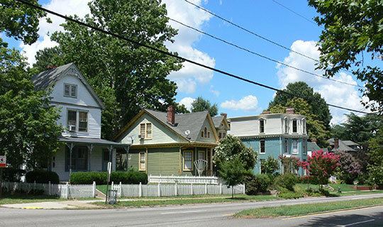
Woodland Heights, VA is a neighborhood in the city of Richmond, Virginia. It began as a trolleycar neighborhood in the early 1900s and was built up along the James River beside Forest Hill Park. Woodland Heights is listed on the National Register of Historic Places and the Virginia Landmarks Registry.
Contents
Map of Woodland Heights, Richmond, VA 23225, USA
History
Woodland Heights was first advertised in 1891 as a luxury riverside retreat with proximity to downtown Richmond and Forest Hill Park. At this time, the "South Bank" of the James River was still mainly farms and woodlands along Old Manchester's western edge. Woodland Heights is the oldest of three sister neighborhoods built along the Rhodes trolleycar line, along with Westover Hills and Forest Hill.
Architecture
Amongst the first homes built in Woodland Heights was the T.D. Mann House. It was built in 1890, in the popular Victorian Queen Anne style.
Many subsequent homes built in Woodland Heights were of the American Four Square design from the Sears Roebuck catalog.
Notable events
Woodland Heights holds an annual House Tour and craft fair. It is located within walking distance of Forest Hill Park, Canoe Run Park, and Carter Jones Park. Forest Hill Park holds a farmer's market on Saturdays.