
Population 6,265. 2011 Census Civil parish Southbourne Area 10.68 km² UK parliament constituency Chichester | OS grid reference SU769056 Dialling code 01243 | |
 | ||
Southbourne is a village and civil parish in the Chichester District of West Sussex, England. It lies to the east of Emsworth, the west of Chidham (recently the boundary has been changed) and south-east of Westbourne. Southbourne Parish comprises Lumley, Hermitage, Thornham, Prinsted and part of Nutbourne.
Contents
Map of Southbourne, UK
The parish has a land area of 1068.36 hectares (2639 acres). In the 2011 census 6261 people lived in 2595 households of whom 2762 were economically active. The Parish are undertaking a Neighbourhood Plan and are having to accommodate 350 dwellings within its boundary between 2014 and 2029.
Southbourne has a small railway station on the West Coastway Line between Southampton and Brighton. Southbourne has a separate Infant School and Junior School and is home to Bourne Community College, which takes secondary pupils from around the area. Bourne Leisure centre and a Library both serve surrounding villages and settlements. Our Age Concern and Southbourne Bowls and Social Club are both in New Road. The A259 road, formerly designated A27 and the main coast route until the construction of a new dual carriageway, runs through the village.
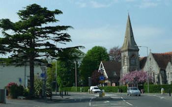
The village encompasses various residential areas and an industrial estate populated mainly with metal work outlets. There are various local shops along the Main Road and Stein Road. The area South of the Main Road with access to Chichester Harbour is known as Prinsted. It has a conservation area with a number of thatched roof properties.
History
Previously part of Westbourne the first mention of Southbourne is Southbourne Council School in 1876, which had previously been Prinsted Board School.
Governance
An electoral ward in the same name exists. The ward includes West Thorney with at the 2011 census a total population of 7,448.
Landmarks
Chichester Harbour, a Site of Special Scientific Interest is partly within the parish. This is a wetland of international importance,a Special Protection Area for wild birds and a Special Area of Conservation. The harbour is of particular importance for wintering wildfowl and waders of which five species reach numbers which are internationally important.
Villages
Other villages in the parish include: Lumley, Hermitage, Prinsted and part of Nutbourne