
Area 7.47 km (2.88 sq mi) Civil parish Westbourne Local time Saturday 6:27 AM | OS grid reference SU756074 Sovereign state United Kingdom Population 2,309 2011 Census | |
 | ||
Weather 10°C, Wind S at 23 km/h, 89% Humidity | ||
Westbourne is a village, civil parish and electoral ward in the Chichester District of West Sussex, England. It is located 0.5 miles (0.80 km) north east of Emsworth. The parish includes the hamlets of Woodmancote and Aldsworth, and once included the settlements of Southbourne and Prinsted to the south. The village stands on the River Ems, a small river flowing into Chichester Harbour at Emsworth. It is believed that the village takes its name from its position on the river, which traditionally marks the westernmost boundary of Sussex, bourne being an archaic term for a boundary as well as for a small river or brook.
Contents
Map of Westbourne, Emsworth, UK
The parish covers an area of 1,846 acres (747 ha). The population of the village in 2011 is 2,309, 1,656 of whom are economically active, and who live in 1,000 households.
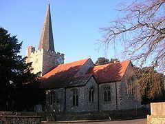
Westbourne contains 66 listed buildings some dating back to the 16th Century, though written evidence of habitation can be found in the Domesday Book of 1086. The medieval Church of St John the Baptist is notable for its fine yew avenue, which is apparently the oldest in England, and walled graveyard. Nicholas Levett, a native of Petworth and fellow of Balliol College, Oxford, was longtime minister of St John the Baptist. He was buried in Beckley, Oxfordshire, in 1687.
Commonside forms the northern edge of the village of Westbourne. This area is centred on a village pub called the Cricketers which is located near the village cricket pitch. There are two other public houses, the White Horse and the Stag's Head, both in The Square, at the centre of the oldest part of the village. Until 2010, a third pub called the Good Intent was open in North Street, but this has now closed and has been converted to a private home.
As of April 2011, the north-eastern and eastern edges of the village now form boundaries with the newly designated South Downs National Park.
Westbourne is part of the Chichester constituency, a safe Conservative seat since 1924. The current member of parliament is Andrew Tyrie MP. As of the May 2013 local elections, Sandra James, who represents the UK Independence Party (UKIP), was elected as County Councillor. She took the seat from long-standing Conservative Councillor Mark Dunn. The District Councillor is Mark Dunn, who won a by-election in Autumn 2013, when Maureen Elliot stood down due to ill health.