
Country Canada Time zone Eastern (EST) (UTC-5) Website South Stormont Population 12,617 (2011) Area code 613 | Formed January 1, 1998 Postal code FSA K0C Area 447.5 km² | |
 | ||
South Stormont is a township in eastern Ontario, Canada, in the United Counties of Stormont, Dundas and Glengarry. Located 53 kilometres (33 mi) southeast of Ottawa, the township was incorporated on January 1, 1998, by amalgamating the former geographic townships of Cornwall and Osnabruck.
Contents
Map of South Stormont, ON, Canada
South Stormont borders on, but does not include, the city of Cornwall.
Communities
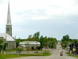
The township comprises the communities of Ault Island, Black River, Bonville, Bush Glen, Bunker Hill, Churchill Heights, Dixon, Gallingertown, Harrison's Corners, Ingleside, Lakeview Heights, Long Sault, Lunenburg, Newington, North Lunenburg, North Valley, Northfield, Northfield Station, Osnabruck Centre, Pleasant Valley, Rosedale Terrace, St. Andrews West, Sandfield Mills and Sandtown. In addition, the township would have been home to the nine Lost Villages which were flooded to create the St. Lawrence Seaway.
Government
The township of South Stormont is governed by three councillors, a deputy mayor and a mayor (reeve). The term length is four years. South Stormont also conducts elections on the internet, using a secure, and cost-efficient website and automated telephone voting system.
History
Cornwall and Osnabruck were two of the original eight "Royal Townships" established along the Saint Lawrence River in Upper Canada. Osnabruck was named after a title formerly held by Prince Frederick, son of George III, who at one time was Prince-Bishop of Osnabrück in Lower Saxony, and Cornwall was named for Prince Frederick's title as Duke of Cornwall.
This area was first settled by members of Sir John Johnson's King's Royal Regiment of New York, and became Stormont County in 1792.
The Lost Villages, ten ghost towns which were flooded by the construction of the Saint Lawrence Seaway in 1958, were located in the former Cornwall and Osnabruck Townships. The communities of Long Sault and Ingleside were newly built to accommodate displaced residents of the flooded villages. Due to this relocation, the towns were entirely planned from their inception - a rarity in Ontario. Several streets in the two communities are named for the flooded settlements.