
OS grid reference TF888243 | Sovereign state United Kingdom Dialling code 01328 | |
 | ||
South Raynham is a village in the county of Norfolk. It is situated on the A1065 road some 5 miles (8.0 km) SW of Fakenham. The River Wensum flows nearby. The village can trace its origins back and before the Domesday survey of 1086 when the village was known as Reinham. At the 2011 Census the population of the village was included in the civil parish of Colkirk.
Contents
Map of South Raynham, Fakenham, UK
The Raynhams
Today, The Raynhams would cover the names of three villages East, West, South Raynham and a large area of park and farmland known as Raynham Park, which the Raynham villages and the 17th century Raynham Hall border.
Raynham Hall
Raynham Hall is a rectangular mansion built of brick and stone dressings. Work commenced in 1619 and was completed in 1630. It is the seat of the Townshend family, and is owned today by the 7th Marquis Townshend.
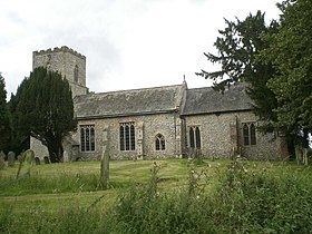
The Church of St Martin
The Church of St Martin dates back to the 14th century and is built from flint and freestone dressings in the Decorated and Perpendicular style of architecture. The most outstanding feature of the church is the mensa, or altar stone. Pevsner believed it might be 12th century, but may be older.
Recreation
Much of the area can be visited by a circular walk, which takes in mixed woodland, water meadows, arable land, and historic buildings, almost entirely on the Raynham estate.