
Population 651 (2011 census) Sovereign state United Kingdom Dialling code 01652 | OS grid reference SE987210 Local time Tuesday 12:51 AM UK parliament constituency Brigg and Goole | |
 | ||
Weather 6°C, Wind E at 6 km/h, 90% Humidity | ||
South Ferriby is a village in North Lincolnshire, England. It is situated on the south bank of the Humber Estuary and 3 miles (5 km) west from the Humber Bridge. North Ferriby is directly opposite on the Estuary’s north bank. Village population was 651 in 2011.
Contents
- Map of South Ferriby Barton upon Humber UK
- South ferriby school past to present part 2
- History
- Geography
- Economy
- References
Map of South Ferriby, Barton-upon-Humber, UK
South ferriby school past to present part 2
History
South Ferriby dates back at least to Roman times when there was a major settlement. It is known locally as one of the 'Low Villages' at the bottom of a chalk escarpment, where the chalk meets the clay to give, before piped water,(the village was one of the first to have piped water with houses plumbing into the supply which was put down to supply steam ships) to the a plentiful water supply. It also marks the point where the Lincolnshire Wolds meet the Humber Estuary and was, as the name suggests, the southern end of an ancient ferry over the Humber to North Ferriby. The entry in the Domesday Book of 1086 records a church, a mill and two ferries. To sustain two ferries suggests that a prosperous trading community must have been flourishing at the time.
South Ferriby was once two villages, Ferriby Sluice with its strong connection to brick manufacture and other activities on the River Ancholme and South Ferriby with two farms that are still operational. The village has a general store with post office, garage, primary school and two public houses:(one public house The Nelthorpe Arms shut 2016) the Nelthorpe Arms, named after the family who at the beginning of the 19th century owned over half the village (and still have major holdings today) and down by the Sluice, the Hope and Anchor which looks out over the Humber with Read's Island and its wildlife.
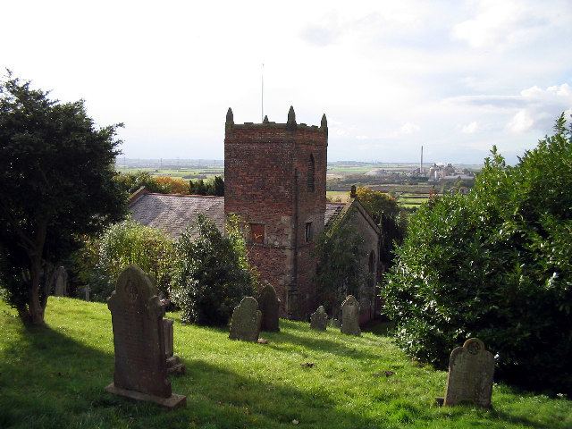
The parish church, dedicated to St Nicholas, appears to be the remnant of a much larger church; it is a structure consisting of nave, south transept, north porch and an embattled tower with pinnacles at the south-east corner containing 3 bells. Over the porch is an ancient semicircular stone, on which is a sculptured figure of St Nicholas, vested in alb and mitre and holding a pastoral staff in his left hand and on either side are symbolical figures of the Sun and Moon. The unusual north-south alignment of the current church is a legacy of a Victorian enlargements of the church. The Creed and Commandment boards survived in the vestry in the 1990s, and the present pulpit is a surviving element of the 18th century two- or three-decker pulpit dismantled during the 1870s reordering of the church. This was the chancel prior to the 1870s, the nave of the church having been rebuilt almost square following a landslip in the late 16th century.
Ferriby Hall is now a private residence once again, having formerly been used as nursing home. Originally a private house until at least the 1960s. In 1953 some contents of the house were lent to Hull Museum on permanent loan. The house was owned in the 1960s by the Booty Family but had to be sold after Leonard Booty, grandson of Frederick Booty absconded with the family inheritance.
The village was badly flooded in the storm surge of December 2013.
Geography
South Ferriby lies on the route of the Viking Way, the 147 miles (237 km) long-distance footpath from the Humber Bridge to Oakham, and is on the side of an escarpment overlooking the Ancholme valley. The A1077 climbs the steep escarpment at this point, and meets the B1204 from the south, which follows the escarpment to Elsham Hall Country Park (former A15 road) via Horkstow. The A1077 is sometimes closed to let boats through the sluice.
Economy
Employment is chiefly in nearby towns, with use of convenient transport links, but with some village home working.
The only industry is the cement works. The plant, owned by Cemex (formerly Rugby Cement, and before that Eastwood's Humber Cement), is a prominent landmark in the village, and obtains its raw material from the Middlegate Lane quarry on the hill above. There is an overhead conveyor belt that passes to the south of the village from the Middlegate Lane quarry to the cement processing works to the south-west over the River Ancholme.