
Topo map USGS Black Nubble Prominence 110 m | Elevation 1,235 m Listing Four-thousand footers | |
 | ||
Mountain range Appalachian Mountains, Rangeley-Stratton Similar Crocker Mountain, Mount Redington, Saddleback Horn, Spaulding Mountain, Mount Abraham | ||
Appalachian trail north south crocker mountains trip video october 2012
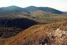
South Crocker Mountain is a mountain located in Franklin County, Maine. South Crocker Mountain is flanked to the north by Crocker Mountain, and to the southwest by Mount Redington.
Contents
- Appalachian trail north south crocker mountains trip video october 2012
- Map of South Crocker Mountain Carrabassett Valley ME 04947 USA
- September 22 2015 summit of south crocker mountain
- References
Map of South Crocker Mountain, Carrabassett Valley, ME 04947, USA
The northeast and southeast faces of South Crocker Mountain drain into the South Branch of the Carrabassett River, which flows into the Kennebec River, and into the Gulf of Maine. The west face of South Crocker drains into Nash Stream, thence into the South Branch of the Dead River, Flagstaff Lake, the Dead River, another tributary of the Kennebec.
The Appalachian Trail, a 2,170 mi (3,490 km) National Scenic Trail from Georgia to Maine, traverses the summit of South Crocker Mountain, running north along the ridge to Crocker, and east across Caribou Valley to Sugarloaf Mountain.