
Car plates BSK | Area 2,054 km² | |
 | ||
Gminas Total 10Gmina Dąbrowa BiałostockaGmina JanówGmina KorycinGmina KrynkiGmina KuźnicaGmina Nowy DwórGmina SidraGmina SokółkaGmina SuchowolaGmina Szudziałowo Points of interest Biebrza National Park, Kruszyniany Mosque, SILVARIUM ‑ ogród leśny, Bohoniki Mosque, Geograficzny Środek Europy | ||
Sokółka County (Polish: powiat sokólski) is a unit of territorial administration and local government (powiat) in Podlaskie Voivodeship, north-eastern Poland, on the border with Belarus. It was created on 1 January 1999 as a result of the Polish local government reforms passed in 1998. Its administrative seat and largest town is Sokółka, which lies 39 kilometres (24 mi) north-east of the regional capital Białystok. The county also contains the towns of Dąbrowa Białostocka, lying 30 km (19 mi) north of Sokółka, Krynki, lying 24 km (15 mi) south-east of Sokółka, and Suchowola, 33 km (21 mi) north-west of Sokółka.
Contents
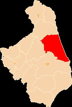
Map of Sok%C3%B3%C5%82ka County, Poland
The county covers an area of 2,054.42 square kilometres (793.2 sq mi). As of 2006 its total population is 72,424, out of which the population of Sokółka is 18,888, that of Dąbrowa Białostocka is 6,147, that of Krynki is 2,709, that of Suchowola is 2,243, and the rural population is 42,437.
Neighbouring counties
Sokółka County is bordered by Białystok County to the south-west, Mońki County to the west and Augustów County to the north-west. It also borders Belarus to the east.
Administrative division
The county is subdivided into 10 gminas (four urban-rural and six rural). These are listed in the following table, in descending order of population.