
Topo map USGS Sylva North | Elevation 1,323 m | |
 | ||
Similar Blue Ridge Mountains, Waterrock Knob, Soco Falls, Balsam Gap, Plott Balsams | ||
A top of soco gap nc
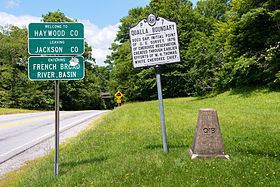
Soco Gap (el. 4,340 ft (1,320 m)) is a mountain pass between the Plott Balsam Range, to its south, and Balsam Mountain, to its north. Also known as Ahalunun'yi (ᎠᎭᎷᏄn'Ᏹ), meaning "Ambush Place" or Uni'halu'na (ᎤᏂ'ᎭᎷ'Ꮎ), meaning "where they ambushed;" named after when the Cherokees ambushed a party of invading Shawnees, all of which were killed except for one, who was sent back to tell his people of the Cherokee victory.
Contents
Map of Soco Gap, Qualla, NC 28751, USA
The gap is the eastern point of the Qualla Boundary, which marks the territory held as a land trust for the federally recognized Eastern Band of Cherokee Indians. The gap also separates Haywood and Jackson counties and separates the river basins to the French Broad and Little Tennessee.
U.S. Route 19 (Soco Road) traverses through the gap, which connects Cherokee and Maggie Valley. The Blue Ridge Parkway also passes through the gap, providing scenic views along the adjacent ridge lines.