
OS grid reference ST841739 Post town CHIPPENHAM Dialling code 01249 | Sovereign state United Kingdom Postcode district SN14 | |
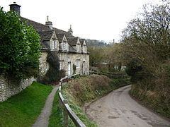 | ||
Slaughterford is a small village and former civil parish about 5 miles (8 km) west of Chippenham, Wiltshire, in the South West of England. The village is at a crossing point of the Bybrook River, in a wooded valley between Castle Combe and Box.
Contents
Map of Slaughterford, Chippenham, UK
History
The Manor Farmhouse is from 1753.
Slaughterford was a separate parish, with its own church, until it was amalgamated with Biddestone in 1844.
The National Gazetteer of Great Britain and Ireland (1868) said of it:
SLAUGHTERFORD, a parish in the hundred of Chippenham, county of Wilts, 5 miles N. W. of Chippenham, its post town, and 9 E. of Bath. The village, which is considerable, is situated on Box brook, a branch of the river Avon. In the vicinity is Bury-Wood camp, on the Fosse Way. The living is a perpetual curacy annexed to the rectory of Biddestone, in the diocese of Gloucester and Bristol. The church, dedicated to St. Nicholas, is an ancient structure with a tower containing one bell.
Religious sites
The church of St Nicholas is Grade II* listed. Built in the 15th century, it was partly destroyed circa 1649 by Cromwell's troops on their way to Ireland, and lay in ruins until it was rebuilt in 1823. There was further restoration in 1883. In 2015 the church was still in use, with services on alternate Sundays.
A Quaker meeting house was in use from the 17th century; it became disused and collapsed in the 1960s.