
Constituency Northeast Constituency Population 399 Municipal number 6607 Area 6,036 km² | Manager Jón Óskar Pétursson Density 0.07/km (0.18/sq mi) Website myv.is Postal code 660 | |
 | ||
Region | ||
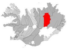
Skútustaðahreppur is a rural municipality located in East Iceland, in Northeastern Region. Its seat is in the village of Reykjahlíð.
Contents
Map of Sk%C3%BAtusta%C3%B0ahreppur, Iceland
Geography
Skútustaðir is one of the largest Icelandic municipalities. Its souther borders are represented by the northern site of the glacier of Vatnajökull. Its territory includes the lakes of Mývatn (in front of Reykjahlíð) and Öskjuvatn; and the volcanoes of Hverfjall, Askja, Krafla and Herðubreið.
References
Skútustaðahreppur Wikipedia(Text) CC BY-SA