
Last eruption 1961 Parent range Dyngjufjöll | Elevation 1,516 m Mountain range Dyngjufjöll | |
 | ||
Similar Herðubreið, Krafla, Hekla, Laki, Bárðarbunga | ||
Askja tours in iceland with local guide www kip is
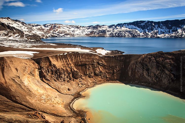
Askja ([ˈascja]) is a caldera situated in a remote part of the central highlands of Iceland. The name Askja refers to a complex of nested calderas within the surrounding Dyngjufjöll mountains, which rise to 1,510 m (4,954 ft), askja meaning box or caldera in Icelandic
Contents
- Askja tours in iceland with local guide www kip is
- Map of Askja Iceland
- Askja volcano iceland facts information visit askja iceland s most famous caldera
- Location
- Eruptions
- skjuvatn lake
- Missing scientists
- Sights and tourism in the area
- References
Map of Askja, Iceland
Askja volcano iceland facts information visit askja iceland s most famous caldera
Location
The region is only accessible for a few months of the year. Being situated in the rain shadow to the northeast of the Vatnajökull glacier, the area receives only about 450 mm of rainfall annually. The area was used during training for the Apollo program to prepare astronauts for the lunar missions. Their main objective in Askja was to study geology.
Eruptions
Askja was virtually unknown until the tremendous eruption which started on March 29, 1875. Especially in the eastern fjords of Iceland, the ashfall was heavy enough to poison the land and kill livestock. Ash, or tephra from this eruption was wind-blown to Norway and Sweden. The eruption triggered a substantial wave of emigration from Iceland. Another less well-known eruption occurred in the early Holocene, ca 11,000 years ago. Tephra from this eruption has been found in south-east Sweden, Northern Ireland and north Norway. The last eruption of Askja was in 1961.
The outer caldera of Askja, representing a prehistoric eruption, is about 50 km², and there is evidence of other later caldera-forming events within it. The main crater floor lies at about 1,100 m.
In June 2010, Volcano expert Hazel Rymer said seismic activity was increasing at Askja and that an eruption could be around the corner The increased earthquake activity is located to the northeast of the central volcano, in the direction of Herðubreið. It was ruled out that any activity from Eyjafjallajökull was responsible for the increase in activity at Askja. The news came as scientists continue to watch Katla.
In early April 2012 it was noted that the lake in the caldera was totally clear of ice, which usually does not happen until in June or July in a normal year. It is believed that increased geothermal activity in the volcano is heating the lake. Travel in the area was restricted until further research could be carried out.
Öskjuvatn lake
Öskjuvatn is a large lake that fills much of the smaller caldera resulting from the 1875 eruption. Its surface lies about 50 m below the level of the main caldera floor and covers about 12 km². When the lake originally formed it was warm, but today it is frozen over for most of the year. Öskjuvatn is the second deepest lake in Iceland at 220 m deep.
Missing scientists
In 1907, the German scientists Walter von Knebel and Max Rudloff visited Askja to study the caldera. While exploring Öskjuvatn in a small boat, they disappeared without a trace. Von Knebel's fiancée Ina von Grumbkow led an expedition to search for them, but no indication of what happened to them was ever found. Recent observations on the effects of a landslide, on 21 July 2014, has led to renewed speculation that the scientists were killed by a similar sudden event, as the result of a massive wave similar to the one seen in 2014. which was estimated to be 30 meters high.
Sights and tourism in the area
In the Dyngjufjöll mountains which surround the Askja caldera can be found the impressive Drekagil, the canyon of dragons. Not far from Askja, there are two other interesting volcanic systems: Herðubreið and Kverkfjöll.
Askja is a popular tourist destination. There are two mountain huts and a campsite at Dreki, by Drekagil, which is about 100 km by a 4x4 F-road, from the Icelandic ring-road. The road continues 8 km up from Dreki into the Askja caldera. It is a walk of about 2.5 km from the car park to Öskjuvatn and Víti. The roads are usually only open for about three to four months, from late June until early October.