
Basin area 372 km² Source Wetland | - elevation 365 m (1,198 ft) - elevation 74 m (243 ft) Province Ontario | |
 | ||
Similar Lake Ontario, Glen Abbey Golf Course, Lions Valley Park, Hilton Falls Conservation Area, Bronte Creek Provincial | ||
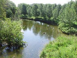
Sixteen Mile Creek is a river in Halton Region in the Greater Toronto Area of Ontario, Canada. It is in the Great Lakes Basin, and flows from the Niagara Escarpment through the towns of Milton and Oakville to Lake Ontario.
Contents
Map of Sixteen Mile Creek, Oakville, ON, Canada
It was previously known to the Mississauga Indians in their language as Ne-sauga y-onk or niizhozaagiwan ("having two outlets") and to the French as Rivière de Gravois ("gravelly river").
Like many creeks draining into Lake Ontario, Sixteen Mile Creek has cut a deep valley that is home to a broad range of wildlife, including whitetail deer, raccoons, foxes, opossum, and squirrels. The forest contains tree species typical of the Carolinian forest habitat, although since this is close to the northern limit of this zone, some are poorly represented. The total area of the drainage basin is 372 square kilometres (144 sq mi).
In Oakville, it also forms part of Glen Abbey Golf Course and is home to the Oakville Yacht Squadron.
TributariesEdit
Invasive SpeciesEdit
Giant hogweed is a non-native invasive plant that is most widely distributed in Halton Region along Sixteen Mile Creek. Contact with this plant can cause serious burns to the skin and temporary or permanent blindness.