
Location South East Asia Highest point unnamed Elevation 567 m | Highest elevation 567 m (1,860 ft) Regency Simeulue Regency Population 82,100 (2007 census) Area 2,310 km² | |
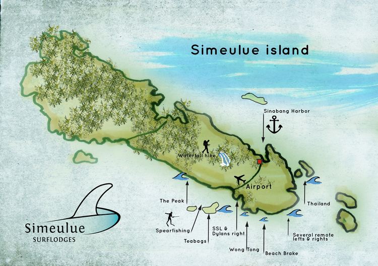 | ||
Simeulue is an island of Indonesia, 150 kilometres (93 mi) off the west coast of Sumatra. Its capital is Sinabang.
Contents
- Map of Simeulue Lauke Central Simeulue Sub District Simeulue Regency Aceh Indonesia
- Torren martyn garrett parkes x simeulue
- Demographics
- 2004 Indian Ocean earthquake
- Local wisdom
- References
Map of Simeulue, Lauke, Central Simeulue Sub-District, Simeulue Regency, Aceh, Indonesia
Simeulue was once a part of West Aceh Regency but was split off in 1999 and became a separate Simeulue Regency.
Torren martyn garrett parkes x simeulue
Demographics
From the ethnic point of view the inhabitants of Simeulue are similar to the people of neighboring Nias Island. Two languages and a number of dialects are spoken on the island: Devayan and Sigulai, which are different from the languages spoken in the north of Sumatra. The majority of the island's population is Muslim.
2004 Indian Ocean earthquake
Simeulue was close to the epicenter of the 9.3 magnitude 26 December 2004 earthquake.
On 28 March 2005, an 8.7 magnitude earthquake struck with its epicenter just off the south end of the island. During the earthquake, Simeulue rose at least six feet on the western coast; this left the flat top of its coral reefs above high tide. On the east coast, the land was submerged, with seawater flooding fields and settlements.
Local wisdom
Although Simeulue Island was only 60 kilometers from the epicenter, while Banda Aceh was about 250 kilometers, only six residents died while the remaining 70,000 persons were safe, due to local wisdom called 'smong'; this dictated that after an earthquake, if the tide suddenly receded, people should evacuate to higher ground as soon as possible.