
Elevation 513.66 m (1,685.2 ft) | Age of rock Precambrian | |
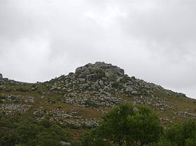 | ||
Peak Cerro Catedral (Cathedral Hill) | ||
Nevada en sierra carap
Sierra Carapé or Sierra de Carapé is a hill range located in Maldonado Department, in southern Uruguay. The range crosses the Maldonado Department from west to east and enters the Rocha Department. It constitutes the border between the departments of Lavalleja and Maldonado. This hill range constitutes part of a larger range named Cuchilla Grande.
Contents
Highest point in Uruguay
This range has the highest point of the country, the Cerro Catedral, with 513.66 metres (1,685.24 feet) of altitude.
References
Sierra Carapé Wikipedia(Text) CC BY-SA