
Country United States Incorporated 1753 Elevation 85 m Zip code 01464 | Settled 1720 Time zone Eastern (UTC-5) Founded 1753 Population 7,211 (2010) | |
 | ||
Weather 1°C, Wind N at 18 km/h, 86% Humidity | ||
Shirley is a town in Middlesex County, Massachusetts, United States. It is approximately fifty miles west-northwest of Boston. The population was 7,211 at the 2010 census. The town has a well-preserved historic New England town center.
Contents
- Map of Shirley MA USA
- History
- Geography
- Demographics
- Schools
- Parks
- Churches
- Points of interest
- Transportation
- Newspapers
- Cable
- Notable people
- References
Map of Shirley, MA, USA
It is home to the Massachusetts Correctional Institution – Shirley, a medium-security state prison. (The neighboring maximum-security Souza-Baranowski Correctional Center lies just outside the town limits in the town of Lancaster.) The remains of a Shaker village have been preserved within the grounds of the prison.
History
The inhabitants at the time of European encounter were Nipmuc (or Pennacook) Indians, who called the area Catacunemaug. Once part of "The Plantation of Groton," Shirley was first settled by English pioneers about 1720.
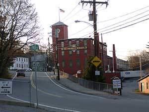
In 1753 it separated from Groton and was incorporated, named in honor of William Shirley, governor of Massachusetts (1741–1757). A paper mill was built here around 1790 and in 1812 Shirley established the first of seven cotton mills. Other local products included iron, nails, textiles, rope, belts, suspenders, and athletic equipment. Two of the large 19th-century mill buildings have been subdivided and adapted for use by 21st-century businesses.
A utopian religious community, Shirley Shaker Village, was established in Shirley in 1793. The Shakers advocated pacifism, common property, celibacy and communal living. They are renowned for their plain architecture and furniture. The Shaker movement peaked in the 1840s, but gradually dwindled, perhaps because of greater employment opportunities offered by the Industrial Revolution, or because succeeding generations grew less tolerant of the Shaker church's insistence on self-abnegation. Shirley Shaker Village closed in 1908.
A medium-security state prison was built on land surrounding the remains of the Shaker village in Shirley, and continues to operate. The town also operates a Senior Center located at 9 Parker Road.
Geography
The town has a total area of 15.9 square miles (41.2 km²), of which 15.8 square miles (41.0 km²) is land and 0.1 square mile (0.2 km²) (0.50%) is water. It is bounded by the Squannacook and Nashua rivers and contains Mulpus Brook and Catecunemaug Brook. Significant wetlands are Spruce Swamp (drained by Spruce Swamp Brook) and Tophet Swamp.
Demographics
This article describes the town of Shirley as a whole. Additional demographic detail is available which describes only the central settlement or village within the town, although that detail is included in the aggregate values reported here. See: Shirley (CDP), Massachusetts.
As of the census of 2000, there were 6,373 people, 2,067 households, and 1,426 families residing in the town. The population density was 402.7 people per square mile (155.5/km²). There were 2,156 housing units at an average density of 136.2 per square mile (52.6/km²). The racial makeup of the town was 83.90% White, 6.72% Black or African American, 0.47% Native American, 2.10% Asian, 0.08% Pacific Islander, 5.12% from other races, and 1.62% from two or more races. Hispanic or Latino of any race were 6.86% of the population.
There were 2,067 households out of which 34.2% had children under the age of 18 living with them, 56.2% were married couples living together, 9.3% had a female householder with no husband present, and 31.0% were non-families. 25.4% of all households were made up of individuals and 8.7% had someone living alone who was 65 years of age or older. The average household size was 2.55 and the average family size was 3.09.
In the town, the population was spread out with 21.7% under the age of 18, 7.6% from 18 to 24, 39.2% from 25 to 44, 22.3% from 45 to 64, and 9.2% who were 65 years of age or older. The median age was 37 years. For every 100 females there were 137.8 males. For every 100 females age 18 and over, there were 151.8 males.
The median income for a household in the town was $53,344, and the median income for a family was $66,250. Males had a median income of $42,078 versus $32,130 for females. The per capita income for the town was $20,556. About 1.9% of families and 3.3% of the population were below the poverty line, including 2.1% of those under age 18 and 4.4% of those age 65 or over.
Schools
Parks
Churches
Points of interest
Transportation
Commuter rail service from Boston's North Station is provided by the MBTA with a stop in Shirley on its Fitchburg Line. The Montachusett Regional Transit Authority (MART) supplies Councils-On-Aging service for elderly and disabled residents.