Post code 049-1103 Population 4,620 (30 Sep 2016) | Area 196.7 km² Local time Sunday 5:37 AM | |
 | ||
Named for Chiri Ochi A place with birds (Ainu language) Weather -1°C, Wind SW at 6 km/h, 94% Humidity Points of interest Shiriuchicho Kyodo Museum, Kobi Hot Spring, Mt. Nanatsudake | ||
Shiriuchi (知内町, Shiriuchi-chō) is a town located in Kamiiso District, Oshima Subprefecture, Hokkaido, Japan.
Contents
- Map of Shiriuchi Kamiiso District Hokkaido Prefecture Japan
- Geography
- Neighboring towns
- History
- Transportation
- Education
- Sister town
- Notable people from Shiriuchi
- References
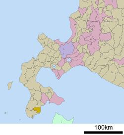
Map of Shiriuchi, Kamiiso District, Hokkaido Prefecture, Japan
As of 2016, the town has an estimated population of 4,620 and a density of 23 persons per km². The total area is 196.66 km².
Geography
Shiriuchi is located on the southwest of the Oshima Peninsula and faces Tsugaru Strait. Shiriuchi River flows through the town.
Neighboring towns
History
Transportation
Kaikyō Line runs through the town, and the entrance of the Seikan Tunnel is in Yunosato. There used to be Shiriuchi Station, but it closed in March 2014.
Education
Sister town
Notable people from Shiriuchi
References
Shiriuchi, Hokkaido Wikipedia(Text) CC BY-SA
