
Population 3,850 (1992) Area 1,839 km² Council seat Warracknabeal | Established 1891 Founded 1891 | |
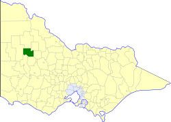 | ||
The Shire of Warracknabeal was a local government area about 200 kilometres (124 mi) west-northwest of Bendigo and 60 kilometres (37 mi) north of Horsham in western Victoria, Australia. The shire covered an area of 1,839 square kilometres (710.0 sq mi), and existed from 1891 until 1995.
Contents
History
The Warracknabeal area was initially within the St Arnaud Road District, first created in 1861, which became a Shire in 1864. On 30 January 1891, its West Riding was severed to create the Shire of Borung. Several boundary changes occurred between 1891 and 1916:
On 7 September 1938 Borung was formally renamed Warracknabeal.
On 20 January 1995, the Shire was abolished, and merged with most of the Shires of Dunmunkle and Shire of Karkarooc and parts of the Wimmera into the Shire of Yarriambiack.
Wards
Warracknabeal was divided into three ridings on 10 November 1987, each of which elected three councillors:
Population
* Estimate in the 1958 Victorian Year Book.