
Population 445 (2006 census) Website Shire of Perry Area 2,358 km² | Established 1880 Founded 1880 Region Wide Bay–Burnett | |
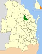 | ||
The Shire of Perry was a local government area in the northern catchment of the Burnett River, Queensland, Australia. The Shire covered an area of 2,357.7 square kilometres (910.3 sq mi), and existed as a local government area from 1880 until 2008, when it amalgamated with several other shires to form the North Burnett Region.
Contents
Its administrative centre was the town of Mount Perry.
History
The Perry Division was one of the original divisions created under the Divisional Boards Act 1879 with a population of 1664. It held its first meeting on 6 March 1880.
With the passage of the Local Authorities Act 1902, Perry Division became the Shire of Perry on 31 March 1903.
On 15 March 2008, under the Local Government (Reform Implementation) Act 2007 passed by the Parliament of Queensland on 10 August 2007, the Shire of Perry merged with the Shires of Biggenden, Eidsvold, Gayndah, Monto and Mundubbera to form the North Burnett Region.
Towns and localities
The Shire of Perry included the following settlement:
Chairmen and mayors
Joy Jensen was the last mayor of the Shire of Perry. Despite leading the smallest of the six North Burnett councils, she won the mayoralty of the new North Burnett Region at the elections on 15 March 2008.