
Population 5,560 (1992) Area 246 km² | Established 1861 Founded 1861 | |
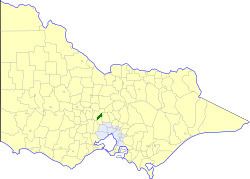 | ||
The Shire of Newham and Woodend was a local government area about 70 kilometres (43 mi) northwest of Melbourne, the state capital of Victoria, Australia. The shire covered an area of 246.05 square kilometres (95.0 sq mi), and existed from 1861 until 1995.
Contents
History
The Woodend, Newham and Rochford Road District was incorporated on 3 December 1861 and became the Shire of Newham on 6 April 1871. Following its union with the Borough of Woodend on 11 January 1905, it became the Shire of Newham & Woodend.
On 19 January 1995, the Shire was abolished, and merged with the Shires of Gisborne, Kyneton and Romsey into the Shire of Macedon Ranges.
Wards
Newham & Woodend was divided into three ridings on 7 May 1953, each of which elected three councillors:
Towns and localities
Population
* Estimate in the 1958 Victorian Year Book.