
Population 3,424 (2006 census) Area 1,445 km² | Established 1912 Founded 1912 | |
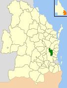 | ||
The Shire of Kilcoy was a local government area in South East Queensland, Australia, about 95 kilometres (59 mi) northwest of Brisbane along the D'Aguilar Highway, not far from the Sunshine Coast. The shire covered an area of 1,445.2 square kilometres (558.0 sq mi), and existed from 1912 until its merger with the Shire of Esk to form the Somerset Region on 15 March 2008.
Contents
Beef cattle is the predominant industry in the area, with other activities including dairying, small crops and aquaculture.
History
The area was originally incorporated as part of the Caboolture Division on 11 November 1879 under the Divisional Boards Act 1879. With the passage of the Local Authorities Act 1902, Caboolture became a Shire on 31 March 1903.
On 22 February 1912, the Shire of Kilcoy split away and was proclaimed in its own right. The council consisted of an elected mayor and eight councillors, and was not subdivided.
On 15 March 2008, under the Local Government (Reform Implementation) Act 2007 passed by the Parliament of Queensland on 10 August 2007, the Shire of Kilcoy merged with the Shire of Esk to form the Somerset Region.
Towns and localities
The Shire of Esk included the following settlements: