
Population 4,870 (1992) Founded 1859 | Established 1859 Area 551.7 km² | |
 | ||
Shire of Creswick | ||
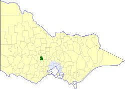
The Shire of Creswick was a local government area about 120 kilometres (75 mi) west-northwest of Melbourne, the state capital of Victoria, Australia. The shire covered an area of 551.66 square kilometres (213.0 sq mi), and existed from 1859 until 1995.
Contents
History
Creswick was first incorporated as a road district on 11 January 1859, and became a shire on 31 December 1863. The Borough of Creswick, incorporated on 19 November 1858 with an area of 19.26 square kilometres (4,759 acres), was united with the shire on 29 May 1934.
On 20 January 1995, the Shire of Creswick was abolished, and, along with the Shire of Daylesford and Glenlyon and parts of the Shires of Kyneton and Talbot and Clunes, was merged into the newly created Shire of Hepburn.
Wards
The Shire of Creswick was divided into four ridings, each of which elected three councillors:
Towns and localities
Population
* Estimate in 1958 Victorian Year Book.