
Population 174 (2011 census) Postal code 3364 | Postcode(s) 3364 Local time Sunday 7:13 AM | |
 | ||
Weather 15°C, Wind SE at 16 km/h, 87% Humidity | ||
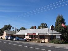
Blampied is a town in the central highlands of Victoria on the Midland Highway. The town is in the Shire of Hepburn, 117 kilometres (73 mi) north west of the state capital of Melbourne. At the 2011 census, Blampied and the surrounding area had a population of 174.
Map of Blampied VIC 3364, Australia
The town was named after Louis Blampied who built a hotel here which is now called the Swiss Mountain Inn.
Blampied Post Office opened on 20 November 1879 and closed in 1971.
References
Blampied, Victoria Wikipedia(Text) CC BY-SA