
Population 4,900 (1992) Council seat Leigh Creek Area 228 km² | Established 1863 Founded 1863 | |
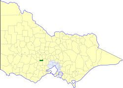 | ||
The Shire of Bungaree was a local government area northeast of the regional city of Ballarat, Victoria, Australia. The shire covered an area of 228 square kilometres (88.0 sq mi), and existed from 1863 until 1994.
Contents
History
Bungaree was first incorporated as a road district on 16 January 1863, and became a shire on 27 January 1871. The shire was originally divided into three ridings in August 1879, but after it lost a small section to the City of Ballaarat on 31 March 1930, it was redivided into two ridings. All divisions were abolished on 6 August 1988, and the council, from then until its dissolution, had nine councillors.
On 6 May 1994, the Shire of Bungaree was abolished, and, along with the Shires of Bacchus Marsh, Ballan and parts of the Shire of Buninyong, was merged into the newly created Shire of Moorabool.
Towns and localities
Population
* Estimate in 1958 Victorian Year Book.