
Phone number 03-3209-1111 Population 337,556 (1 May 2015) | Region Kantō Area 18.23 km² | |
 | ||
Points of interest Shinjuku Gyoen, Kabukichō - Tokyo, Shinjuku Golden Gai, Tokyo Metropolitan Governm, Hanazono Jinja Shrine Colleges and Universities Waseda University, Tokyo University of Science, Kogakuin University, Tokyo Women's Medical, Mejiro University | ||
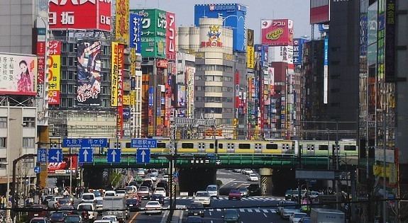
Best of shinjuku tokyo part 1
Shinjuku (新宿区, Shinjuku-ku, "New Lodge") is a special ward in Tokyo, Japan. It is a major commercial and administrative centre, housing the busiest railway station in the world (Shinjuku Station) and the Tokyo Metropolitan Government Building, the administration centre for the government of Tokyo. As of 2015, the ward has an estimated population of 337,556 and a population density of 18,517 people per km². The total area is 18.23 km².
Contents
- Best of shinjuku tokyo part 1
- Map of Shinjuku Tokyo Japan
- Best of shinjuku tokyo part 3
- Geography and neighborhoods
- History
- Economy
- Government and politics
- Elections
- Transportation
- Rail
- Roads
- Colleges and universities
- Schools
- Libraries
- Hospitals
- Museums
- Halls
- Sister cities
- References
Map of Shinjuku, Tokyo, Japan
Best of shinjuku tokyo part 3
Geography and neighborhoods
Shinjuku is surrounded by Chiyoda to the east; Bunkyo and Toshima to the north; Nakano to the west, and Shibuya and Minato to the south.
The current city of Shinjuku grew out of several separate towns and villages, which have retained some distinctions despite growing together as part of the Tokyo metropolis.
"Shinjuku" is often popularly understood to mean the entire area surrounding Shinjuku Station, but the Shinjuku Southern Terrace complex and the areas to the west of the station and south of Kōshū Kaidō are part of the Yoyogi district of the special ward of Shibuya.
Naturally, most of Shinjuku is occupied by the Yodobashi Plateau, the most elevated portion of which extends through most of the Shinjuku Station area. The Kanda River runs through the Ochiai and Totsuka areas near sea level, but the Toshima Plateau also builds elevation in the northern extremities of Totsuka and Ochiai. The highest point in Shinjuku is Hakone-san in Toyama Park, 44.6 m above sea level.
History
In 1634, during the Edo period, as the outer moat of the Edo Castle was built, a number of temples and shrines moved to the Yotsuya area on the western edge of Shinjuku. In 1698, Naitō-Shinjuku had developed as a new (shin) station (shuku or juku) on the Kōshū Kaidō, one of the major highways of that era. Naitō was the family name of a daimyō whose mansion stood in the area; his land is now a public park, the Shinjuku Gyoen.
In 1920, the town of Naitō-Shinjuku, which comprised large parts of present-day Shinjuku (the neighbourhood, not the municipality), parts of Nishi-Shinjuku and Kabukichō was integrated into Tokyo City. Shinjuku began to develop into its current form after the Great Kantō earthquake in 1923, since the seismically stable area largely escaped the devastation. Consequently, West Shinjuku is one of the few areas in Tokyo with many skyscrapers.
The Tokyo air raids from May to August 1945 destroyed almost 90% of the buildings in the area in and around Shinjuku Station. The pre-war form of Shinjuku, and the rest of Tokyo, for that matter, was retained after the war because the roads and rails, damaged as they were, remained, and these formed the heart of the Shinjuku in the post-war construction. Only in Kabuki-cho was a grand reconstruction plan put into action.
The present ward was established on March 15, 1947 with the merger of the former wards of Yotsuya, Ushigome, and Yodobashi. It served as part of the athletics 50 km walk and marathon course during the 1964 Summer Olympics.
In 1991, the Tokyo Metropolitan Government moved from the Marunouchi district of Chiyoda to the current building in Shinjuku. (The Tokyo International Forum stands on the former site vacated by the government.)
Economy
The area surrounding Shinjuku Station is a major economic hub of Tokyo. Many companies have their headquarters or Tokyo offices in this area, including regional telephone operator NTT East, global camera and medical device manufacturer Olympus Corporation, electronics giant Seiko Epson, video game developer Square Enix, fast food chains McDonald's Japan and Yoshinoya, travel agency H.I.S., Fuji Heavy Industries (Subaru), railway operator Odakyu Electric Railway, construction giant Taisei Corporation, medical equipment manufacturer Nihon Kohden, Enoki Films, navigation software company Jorudan, instant noodle giant Nissin Foods and regional airline Airtransse. The station area also hosts numerous major retailers such as Mitsukoshi, Isetan, Takashimaya, Marui, Bic Camera, Yodobashi Camera and Yamada Denki.
Northeastern Shinjuku has an active publishing industry and is home to the publishers Shinchosha and Futabasha.
Government and politics
Like the other wards of Tokyo, Shinjuku has a status equivalent to that of a city. The current mayor is Kenichi Yoshizumi. The ward council (区議会, kugikai) consists of 38 elected members; the Liberal Democratic Party and New Komeitō Party together currently hold a majority. The Democratic Party of Japan, Japanese Communist Party and the Social Democratic Party are also represented together with four independents. Shinjuku's city office (区役所, kuyakusho) is located on the southeastern edge of Kabukichō.
Shinjuku is also the location of the metropolitan government of Tokyo. The governor's office, the metropolitan assembly chamber, and all administrative head offices are located in the Tokyo Metropolitan Government Building. Technically, Shinjuku is therefore the prefectural capital of Tokyo; but according to a statement by the governor's office, Tokyo (the – as administrative unit: former – Tokyo City, the area of today's 23 special wards collectively) can usually be considered the capital of Tokyo (prefecture/"Metropolis") for geographical purposes. The Geographical Survey Institute (Kokudo Chiriin) names Tōkyō (the city) as capital of Tōkyō-to (the prefecture/"Metropolis").
Elections
Transportation
Shinjuku is a major urban transit hub. Shinjuku Station sees an estimated 3.64 million passengers pass through each day, making it the busiest station in the world. It houses interchanges to three subway lines and three privately owned commuter lines, as well as several JR lines.
Rail
A list of railway lines passing through and stations located within Shinjuku includes:
Roads
Other major routes:
Colleges and universities
Schools
Public elementary and junior high schools in Shinjuku are operated by the Shinjuku City Board of Education. Public high schools are operated by the Tokyo Metropolitan Government Board of Education.
Libraries
Shinjuku operates several public libraries, including the Central Library (with the Children's Library), the Yotsuya Library, the Tsurumaki Library, Tsunohazu Library, the Nishi-Ochiai Library, the Toyama Library, the Kita-Shinjuku Library, the Okubo Library, and the Nakamachi Library. In addition there is a branch library, Branch Library of Central Library in the City Office, located in the city office.
Hospitals
There are several major hospitals located within the city limits.
Museums
Halls
Sister cities
Shinjuku has sister city agreements with several localities: