
OS grid reference TQ070479 Sovereign state United Kingdom Local time Saturday 9:06 AM UK parliament constituency Mole Valley | Civil parish Shere Area 9.88 km² Dialling code 01483 | |
 | ||
Population 1,032 (2011)(relevant part of Civil Parish, whole parish had 3,630 people over 24.5 km²) Weather 10°C, Wind S at 16 km/h, 88% Humidity | ||
Winkworth guildford are selling a lovely family house just outside shere surrey tel 01483 339977
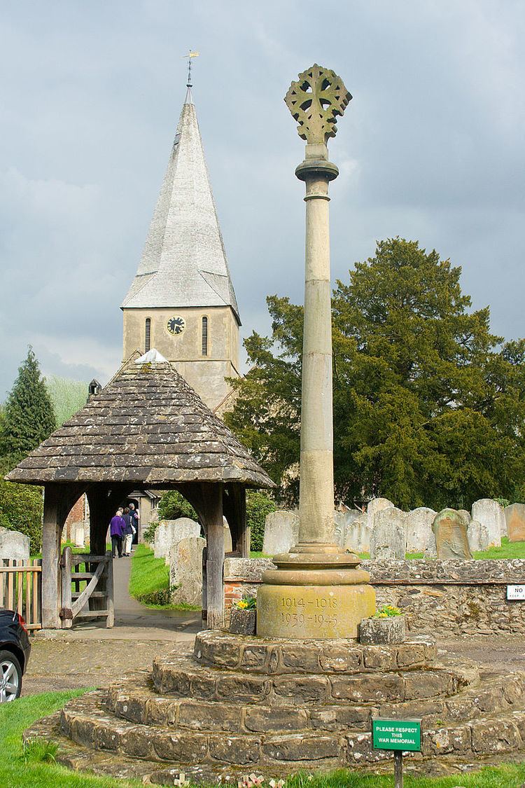
Shere is a village in the Guildford district of Surrey, England 4.8 miles (7.7 km) east south-east of Guildford and 5.4 miles (8.7 km) west of Dorking, centrally bypassed by the A25. It is a small still partly agricultural village chiefly set in the wooded 'Vale of Holmesdale' between the North Downs and Greensand Ridge with many traditional English features. It has a central cluster of old village houses, shops including a blacksmith and trekking shop, tea house, art gallery, two pubs and a Norman church. Shere has a museum which opens most afternoons at weekends.
Contents
- Winkworth guildford are selling a lovely family house just outside shere surrey tel 01483 339977
- Map of Shere Guildford UK
- Domesday book and manors
- Medieval to 19th century
- 19th century
- Church
- Others
- Transport
- Economy demography and housing
- Local government
- Notable residents
- Film location
- Books featuring Shere
- References
Map of Shere, Guildford, UK
The Tillingbourne river runs through the centre of the village. More than four-fifths of homes are in the central area covering 3.11 square kilometres (1.20 sq mi); the northern area of Shere on the North Downs without any named hamlets, including the public hilltop park of Newlands Corner, covers 6.77 square kilometres (2.61 sq mi).
Shere is also a civil parish, extending to the east and south into hamlets founded in the early Middle Ages which officially, in the 19th century, were consolidated into three villages. These are Gomshall, Holmbury St. Mary and Peaslake. This larger entity has a total population of 3,359 and area of 24.5 square kilometres (9.5 sq mi) (as at the 2011 census).
Domesday book and manors
Shere appears in Domesday Book of 1086 as Essira and Essire. It was held by William the Conqueror. Its Domesday assets were: 1 church, 2 mills worth 10s per year, 14 ploughs, 3 acres (1.2 ha) of meadow, woodland worth 50 hogs. It rendered £15 per year to its overlords.
In 1086, when Gomshall was royal demesne, the villeins (villagers) there were exempt from the sheriff's jurisdiction; Gomshall Netley and Gomshall Towerhill manors had court baron. Eleanor, Countess of Ormond owning the Vachery manor, had view of frankpledge in Gomshall Towerhill. In 1281 William Braose was granted free warren there
In the 13th century Roger de Clare settled for a life-rent on the church and sold the manor of Shere to a grandson of Geoffrey Fitz Peter, 1st Earl of Essex. In turn his grandson divided the manor, according with the law of moiety title to his daughter John Butler who thus received the new manor of Shiere Vachery; while Richard Óg de Burgh, 2nd Earl of Ulster ('the red Earl') received Shiere Ebor(acum). Two other manors evolved.
Highlights of the often influential tapestry of powerful owners include (but are not limited to):
Medieval to 19th century
The Victoria County History (Surrey: 1911) cites numerous mentions in the Assize Rolls, Patent Rolls, Feet of Fines and the ecclesiastical records of Westminster and Lambeth Palaces. Traditionally the parish included the areas of the current civil parish and measured about 4½ miles from north to south, and from 2 to 2½ miles from east to west and contained 6,400 acres of land and 12 of water.
The neighbourhood was for a time one of the wildest in Surrey: sheep-stealers, smugglers, and poachers found a refuge in these remote hills. Some of the cottages have, still existing, very large cellars (excavated easily in the sandy hill), stated to have been by H.E. Malden "far too large for any honest purpose, and were no doubt made for storing smuggled goods till they could be conveniently taken on to London".
In 1671, a Shere man called Edward Bound was charged by church authorities with "playing cricket on the Sabbath" and was exonerated, one of the sport's earliest references.
Iron was worked from the stone and into implements in centuries before the 18th century in Shere. In 1911 great quantities of watercress were grown which is no longer the case; the principal area in southern England for this being near the Watercress Line, a railway in Hampshire.
19th century
Holmbury St. Mary up in the Greensand Ridge was a modern village term devised in 1878 for the two hamlets of Felday in Shere and Pitland Street in Shere and Abinger, when the place became a civil parish and ecclesiastical parish. The schools (that is, Church of England ones) were built in 1860 and enlarged in 1900.
Church
The church is Norman, most being 12th, 13th and 14th century, of ironstone rubble with sandstone buttresses, restored in 1895 by S. Weatherley. By the north chancel wall there is a 14th-century quatrefoil window and squint – belonging to Anchorite Cell. There is 14th-century glass in the east window and the chancel fittings were renewed in 1956 by Louis Osman.
Others
Within the village centre conservation area are 34 listed buildings that pre-date 1830, in some cases by several centuries.
Transport
The village can be accessed for long distance travel from the north and west from the A3 at West Clandon – from the east the M25 at Leatherhead and the A24 at Dorking followed by the A25 road provides a shorter alternative route than taking the first route; there are minor routes south however the nearest major route directly south is the A24 at Dorking.
Gomshall railway station is less than 1 mile (1.6 km) away on the Reading to Gatwick line. While 1614 people (65% of the parish) in 2001 for instance were economically active, only 178 routinely used public transport and 1037 used motor vehicles. The average Shere commuter travels 20.3 kilometres (12.6 mi) to work.
Economy, demography and housing
The economy is a mixture of local and regional with the many shops and some farming within it. A significant minority of the working population are London commuters, particularly in the civil parish at large. The 2001 census shows the self-employed (including with employees) form 36% of the population, retirees form 16% of the population and employees form 48% of the population. 77% of the ward's population is Christian, of the remainder 22% are of no religion or not stated.
Within the civil parish are shops, four village halls, and three post offices. Many walks radiate from the village, including a streamside walk, parts of the North Downs Way and the Pilgrims' Way. In the village are Millstream Press, a book publisher named after the Tillingbourne, a textiles-cum-boutique and Surrey Hills Brewery.
The United Kingdom Census 2011 considered the village as four relevant output layers, approximately a third of the ward Shere, the latter being used for elections to Guildford Borough Council. All parts featured their single largest proportion of housing as either semi-detached or single-family homes and most of these with gardens.
In all 439 households (in slightly fewer homes) make up the village including its scattered farms and cottages. The census boundaries drawn exclude central and eastern Burrows Cross due to is proximity to slightly larger hamlet Gomshall, being contiguous and due south Burrows Cross had census overlap of its output areas (E00155528 and E00155529) and was included within Gomshall.
The proportion of households in three divisions of Shere who owned their home outright was at least 5% above the national average, in the fourth division this was 3% below, a central area including one of the two conservation area thoroughfares. The proportion of residents who owned their home with a loan was between 2.8% and 11.3% lower than the national average. The census shows that overall, Shere has a lower proportion than average of rented residential property and of social housing relative to the Surrey and national averages.
Across the whole parish the 2011 distribution of housing was:
The average level of accommodation in the region composed of detached houses was 28%, the average that was apartments was 22.6%.
Local government
At Surrey County Council, one of the 81 representatives represents the area within the Shere division which includes Albury and (East and West) Clandon.
At Guildford Borough Council most wards of the borough are deemed appropriate to be represented under the current constitution of councillors by two to three councillors, which is the case for the Tillingbourne ward which has two.
Notable residents
Film location
Even in 1911, the draws of a picturesque valley and authentic Tudor and similar architecture was considered among the finest in England, as such it has been used for numerous films, the Victoria County History which was written for the county of Surrey in 1911 lavished more praise than on any other village:
.
Books featuring Shere
Anchoress of Shere by Paul L. Moorcraft. The Passionate Friends a social commentary novel by H. G. Wells places the protagonist's marriage here.