
Elevation 4,397 ft (1,340 m) Country United States Mountains Elliott Knob | Length 73 mi (117 km) Highest point Elliott Knob | |
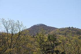 | ||
Location Flagpole Knob in Rockingham County, VA Similar Reddish Knob, Allegheny Mountains, Shenandoah Valley, Great North Mountain, Elliott Knob | ||
Shenandoah Mountain is a mountain ridge approximately 73 miles (117 km) long in Virginia and West Virginia. The steep, narrow, sandstone-capped ridge extends from northern Bath County, Virginia to southern Hardy County, West Virginia. Along the way, its crest defines the borders between Highland and Augusta counties, Virginia, and between Pendleton County, West Virginia, and Rockingham County, Virginia. The name comes from the Iroquoian word for 'deer'.
Located in the Ridge and Valley physiographic province of the Appalachian Mountains, Shenandoah Mountain forms part of the western margin of the Shenandoah Valley, and is part of the easternmost Allegheny Mountains. It lies almost entirely within the George Washington National Forest. U.S. Route 33 crosses the mountain between Franklin, West Virginia, and Harrisonburg, Virginia.
Shenandoah Mountain's highest peaks are Reddish Knob (Virginia/West Virginia; 4397’/1340 m [1]), Flagpole Knob (Virginia; 4383’/1336 m [2]), and Bald Knob (Virginia; 3680’/1122 m [3]).