
Area 1,531 km² Population 11,961 (2013) | Website www.shco.org Founded 1851 Unemployment rate 2.6% (Apr 2015) | |
 | ||
Rivers Silver Creek, Pigeon Creek, Elk Creek, Wolf Creek Points of interest Danish Windmill, Prairie Rose State Park, Museum of Danish America, J J Jensen Baseball - Softball | ||
Shelby County is a county located in the U.S. state of Iowa. As of the 2010 census, the population was 12,167. The county seat is Harlan. Its name is in honor of Isaac Shelby, the first Governor of Kentucky.
Contents
- Map of Shelby County IA USA
- History
- Geography
- Major highways
- Adjacent counties
- 2010 census
- 2000 census
- Census designated places
- Other unincorporated places
- Population ranking
- References
Map of Shelby County, IA, USA
History
Shelby County was formed on January 15, 1851. It was named after General Isaac Shelby, a hero in the American Revolutionary War and the first Governor of Kentucky.
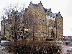
Early settling in Shelby County began in 1848 in Galland’s Grove. On February 4, 1855, Shelbyville was designated the county seat. In April, 1859, the seat was moved to Harlan. One year later the first courthouse was erected and a second courthouse was constructed in 1875. In 1892, the construction of the present courthouse was begun, this time of stone and three storeys high. The construction was completed in 1893 with the dedication on September 14. The 1892 Shelby County Courthouse and the surrounding buildings are all listed in the National Register of Historic places effective September 23, 1994. In 1978, the building was extensively restored and still serves as the courthouse.
Geography
According to the U.S. Census Bureau, the county has a total area of 591 square miles (1,530 km2), of which 591 square miles (1,530 km2) is land and 0.6 square miles (1.6 km2) (0.1%) is water.
Major highways
Adjacent counties
2010 census
The 2010 census recorded a population of 12,167 in the county, with a population density of 20.5931/sq mi (7.9510/km2). There were 5,542 housing units, of which 5,085 were occupied.
2000 census
As of the census of 2000, there were 13,173 people, 5,173 households, and 3,703 families residing in the county. The population density was 22 people per square mile (9/km²). There were 5,459 housing units at an average density of 9 per square mile (4/km²). The racial makeup of the county was 98.68% White, 0.10% Black or African American, 0.29% Native American, 0.27% Asian, 0.18% from other races, and 0.48% from two or more races. 0.67% of the population were Hispanic or Latino of any race.
There were 5,173 households out of which 32.60% had children under the age of 18 living with them, 62.30% were married couples living together, 6.80% had a female householder with no husband present, and 28.40% were non-families. 25.20% of all households were made up of individuals and 13.60% had someone living alone who was 65 years of age or older. The average household size was 2.49 and the average family size was 2.99.
In the county, the population was spread out with 26.40% under the age of 18, 5.70% from 18 to 24, 25.20% from 25 to 44, 22.40% from 45 to 64, and 20.40% who were 65 years of age or older. The median age was 40 years. For every 100 females there were 95.90 males. For every 100 females age 18 and over, there were 93.30 males.
The median income for a household in the county was $37,442, and the median income for a family was $44,681. Males had a median income of $29,402 versus $20,296 for females. The per capita income for the county was $16,969. About 4.30% of families and 6.00% of the population were below the poverty line, including 6.00% of those under age 18 and 7.60% of those age 65 or over.
Census-designated places
Other unincorporated places
Population ranking
The population ranking of the following table is based on the 2010 census of Shelby County.
† county seat