
Population 558 (in 2011) Sovereign state United Kingdom Local time Friday 11:24 AM | OS grid reference SU3163 Post town Marlborough Dialling code 01672 UK parliament constituency Devizes | |
 | ||
Weather 13°C, Wind S at 24 km/h, 77% Humidity | ||
Shalbourne is a civil parish in the English county of Wiltshire, about 3 miles (4.8 km) southwest of Hungerford, Berkshire. Besides a village of the same name, the parish has a number of widely spaced small settlements including Bagshot and Stype, to the north, and Rivar and Oxenwood to the south. Before 1895, about half of the parish of Shalbourne (including its church) lay in Berkshire.
Contents
Map of Shalbourne, Marlborough, UK
Local government
The civil parish elects a parish council. It is in the area of Wiltshire Council unitary authority, which is responsible for all significant local government functions.
Amenities
Shalbourne has a primary school and a village hall which was built in 1843 as a schoolroom.
Notable people
Notable buildings
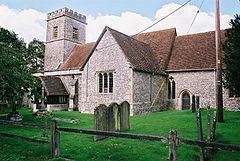
The Anglican Church of St Michael and All Angels is Grade II* listed. It dates from the 13th century and was partly rebuilt and extended by G.F. Bodley in 1873. Stained glass by Henry Haig was added in 1995.
Also Grade II* listed are West Court farmhouse and Shalbourne Manor farmhouse.