
Country United States County Norfolk Incorporated 1635 Area 55.94 km² Population 55,419 (2013) | State Massachusetts Settled 1622-23, 1623 Elevation 200 ft (27 m) Local time Saturday 11:28 AM Mayor Robert L. Hedlund | |
 | ||
Weather 2°C, Wind NE at 26 km/h, 94% Humidity | ||
Weymouth is a city in metropolitan Greater Boston. As of the 2010 census, Weymouth had a total population of 53,743. Weymouth is one of fourteen Massachusetts municipalities that have applied for, and been granted, city forms of government but wish to retain "The town of" in their official names. It is named after Weymouth, Dorset, a coastal town in England. It is the second-oldest European settlement in Massachusetts.
Contents
- Map of Weymouth MA USA
- Demographics
- Income
- Geography
- Climate
- Transportation
- Government
- Education
- A failed colony
- Post Colonization
- Points of interest
- References
Map of Weymouth, MA, USA
Demographics
As of the census of 2010, there were 53,743 people, 22,435 households, and 13,595 families residing in the city. The population density was 3,174.2 people per square mile (1,225.4/km²). There were 22,573 housing units at an average density of 1,327.1 per square mile (512.4/km²). 75% housing units were owner-occupied and 25% of housing units were renter-occupied. The racial makeup of the city was 89.7% White, 3.1% Black or African American, 0.2% Native American, 3.2% Asian, 0.0% Pacific Islander, 0.6% from other races, and 1.2% from two or more races. Hispanic or Latino of any race were 2.1% of the population.
There were 22,028 households out of which 27.3% had children under the age of 18 living with them, 48.6% were married couples living together, 10.3% had a female householder with no husband present, and 26.8% were non-families, 37% of which were non-family households with residents over 65 years of age. 30.6% of all households were made up of individuals and 11.1% had someone living alone who was 65 years of age or older. The average household size was 2.42 and the average family size was 3.08.
In the city, the population was spread out with 22.0% under the age of 18, 6.6% from 18 to 24, 32.7% from 25 to 44, 23.4% from 45 to 64, and 15.4% who were 65 years of age or older. The median age was 38 years. For every 100 females there were 90.4 males. For every 100 females age 18 and over, there were 86.3 males.
The median income for a household in the city was $41,665, and the median income for a family was $54,083. Males had a median income of $42,497 versus $35,963 for females. The per capita income for was $24,976. About 9.1% of families and 9.8% of the population were below the poverty line, including 7.3% of those under age 18 and 7.4% of those age 65 or over.
Weymouth has the 10th highest Irish population in the United States, at 33%.
Income
Data is from the 2009-2013 American Community Survey 5-Year Estimates.
Geography
Weymouth is located at 42°12′23″N 70°56′45″W (42.206458, -70.945919).
According to the United States Census Bureau, the city has a total area of 21.6 square miles (56.0 km²), of which, 17.0 square miles (44.1 km²) of it is land and 4.6 square miles (11.9 km²) of it (21.29%) is water.
Weymouth contains the Weymouth Back River and the Weymouth Fore River; its surroundings, formerly industrial, are now set aside as parks and natural areas including Webb Memorial State Park. There are also a lot of streets named after people and trees.
Weymouth residents often designate which of four distinct 'districts' they live in.
Weymouth is bordered on the north by Hingham Bay. Weymouth's territory includes Grape Island, Slate Island, and Sheep Island, all part of the Boston Harbor Islands National Recreation Area. Weymouth is bordered on the west by Quincy, Braintree, and Holbrook. It is bordered on the south by Abington and Rockland. Weymouth is bordered on the east by Hingham.
Climate
The climate in this area is characterized by hot, humid summers and generally mild to cool winters. According to the Köppen Climate Classification system, Weymouth has a humid subtropical climate, abbreviated "Cfa" on climate maps.
Transportation
Weymouth is served by several MBTA Bus routes as well as three MBTA Commuter Rail stations: two on the Greenbush Line, at Weymouth Landing and near Jackson Square, and one on the Old Colony Line at South Weymouth. Numbered routes that pass through Weymouth include Massachusetts Routes 3, 3A, 18, 53, 58 and 139.
Government
Weymouth was founded in 1635, from the territory known as Wessagusett which was described in 1622—just two years after the Pilgrims landed in Plymouth. Weymouth held the distinction of having the oldest continuous Town Meeting form of government for 365 years. In 1999, Weymouth residents voted to change to a city form of government. David M. Madden was elected as the city's first mayor and took office in 2000.
On July 10, 2007, Mayor David M. Madden announced he would not seek re-election. In 2008, Susan Kay was elected as the new mayor of Weymouth.
On November 3, 2015, Republican state senator Robert L. Hedlund was elected as the new mayor of Weymouth, succeeding long-incumbent mayor Susan M. Kay. Hedlund assumed office on January 4, 2016.
Education
Weymouth High School is the one high school in Weymouth. Prior to 2005, grades eight and nine were housed in Weymouth Junior High while grades ten, eleven, and twelve comprised the High School. This changed with the construction of a new wing on the Junior High building in South Weymouth, which subsequently became the new Weymouth High School housing grades nine through twelve. The old Weymouth High School in East Weymouth was converted into the Maria Weston Chapman Middle School. More than 2,000 students attend the high school. A brand new athletic surface was completed in 2005, giving Weymouth High School an artificial turf field and a track surface.
In 2008 Boston Magazine ranked Weymouth High School number eight among Boston area high schools in academic performance and eighteenth in cost efficiency.
There is one Weymouth Middle School in East Weymouth.There are two campuses and are down the street from each other. The campuses are called Chapman Campus and Adams Campus.
Abigail Adams Middle School has now been set for 5th and 6th grades and Maria Weston Chapman Middle School 7th and 8th grades in 2010.
There are eight primary schools and one early childhood center, five of which are named after Weymouth's Congressional Medal of Honor recipients.
There is one Public Charter School which Weymouth is associated to
In addition, there are five private schools in Weymouth.
A failed colony
The site of Weymouth first saw European inhabitants in 1622 as Wessagusset Colony, a colony founded by Thomas Weston, who had been the main backer of the Plymouth settlement. The settlement was a failure. The sixty men taken from London were ill-prepared for the hardships required for survival. They also may have lacked the motivation of the Pilgrims as this colony was purely economic in motivation and the men had not brought their families.
By winter, poor planning and bad management led to supplies running out. With the Plymouth colonists having few supplies to share, the Weymouth men began to steal from the local Massachusetts nation. Foraging in cooperation with the Pilgrims and trading with Natives was insufficient, and some colonists began to steal from the natives. By now, many in the colony were ill and all forms of law and order had broken down. The lowest point came when a healthy settler was caught stealing supplies from the Massachusetts and the Massachusetts leaders demanded the thief's execution; the Weymouth men complied but either executed or failed to substitute for execution a dying, sick settler instead.
By April 1623, word of conflict between Native Americans and the Virginia colonists had reached the north and this increased the tension between the two groups. Massachusetts and other native groups began plotting to attack and destroy what was left of the floundering Wessagusset colony and possibly the more successful Plymouth Colony. Massasoit heard about it and sent word to Plymouth. Bradford, fearing that Plymouth would also be destroyed, sent Myles Standish to Weymouth with the Plymouth militia to end the threat. Under a banner of truce Standish lured five of the more bellicose Massachusetts Natives inside the stockade. There, after a brief struggle, the native leaders were killed. Ten of the original sixty had starved to death and two others had been killed in conflict with the Natives. Forty-five colonists joined Plymouth or went north to Maine, and from there most returned to England. The three who remained were subsequently killed by Native Americans.
Robert Gorges attempted to form a colony at the site later that year as the center of a more royalist and Anglican system of government for New England. He brought William Morrell as religious leader and expected Governor Bradford to acknowledge his supremacy and act as his agent Within weeks the New England winter caused Gorges to leave with most of the settlers. Those who remained formed the nucleus of the permanent settlement, the second oldest in New England, and the oldest in what would become Massachusetts Bay Colony. In 1630 it was officially incorporated into the Massachusetts Bay Colony and in 1635 with the addition of 100 families under the leadership of Joseph Hull the name was changed to Weymouth. While the integration of these groups did not commence without difficulty, especially due to conflicting pressures from the Puritans of Boston and the Pilgrims of Plymouth, Weymouth was a stable and prominent town with its current boundaries by 1635. Weymouth was included as part of Suffolk County when it was formed on 10 May 1643.
Post Colonization
Weymouth was heavily involved in the shoemaking industry from the first years of the 18th century right through to 1973, when the Stetson Shoe Company closed its doors. The building is currently being used for medical offices.
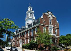
The original town hall, which was destroyed by fire in 1914, was replaced in 1928 with a town hall that is a replica of the old Massachusetts State House in Boston. (Another replica of the building can be found at Curry College in Milton.)