
Elevation 1,310 m (4,300 ft) Postal code 39030 | Area 80 km² Local time Thursday 9:20 PM Dialling code 0474 | |
 | ||
Region Trentino-Alto Adige/Südtirol Frazioni Kiniger (Quiniga), Mitterberg (Monte di Mezzo), Schmieden (Ferrara), St. Veit (San Vito), Moos (Moso) Demonym(s) German: SextnerItalian: di Sesto Weather 9°C, Wind SW at 3 km/h, 61% Humidity | ||
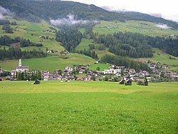
Sexten ( [ˈsɛkstn̩]; Italian: Sesto [ˈsɛsto]) is a comune in South Tyrol in northern Italy. The town is famous as a summer and winter sport resort in the mountains.
Contents
- Map of 39030 Sexten Province of Bolzano South Tyrol Italy
- Geography
- History
- Coat of arms
- Twin towns
- References
Map of 39030 Sexten, Province of Bolzano - South Tyrol, Italy
According to the 2011 census, 95.37% of the population speak German, 4.36% Italian and 0.27% Ladin as first language.
Geography
The town sits in a branch of the Puster Valley, near Innichen and Toblach, where the Drava rises. The district borders East Tyrol, Austria, to the north and the border is formed by the Carnic Alps. To the south lie the eponymous Sexten Dolomites and nature park, which includes the famous Drei Zinnen (Tre Cime di Lavaredo).
The commune is bordered, clockwise from the west, by Toblach, Innichen, Sillian (Austria), Kartitsch (Austria), Comelico Superiore (Belluno) and Auronzo di Cadore, (Belluno).
History
The village's name is of Latin origin: ad horam sexta, meaning "at six-hour", referred to its location south to Innichen. Sexta is documented starting from 965 AD. During World War I, Sexten was on the front line between Italy and the Austro-Hungarian Empire, and suffered much damage.
It was conquered by Italy in November 1918. Later it received further fortifications during the Fascist Era.
Coat-of-arms
The emblem is azure and represents three argent peaks with a sable chamois standing in the centre; the three peaks symbolize the Tre Cime di Lavaredo. The emblem was granted in 1972 but was in use before World War I.
Twin towns
Sexten is twinned with: