
Length 400 km (250 mi) Area 20,500 km² | Width 50 km (30 mi) | |
 | ||
Location Severny Island,Novaya Zemlya,Russian Federation | ||
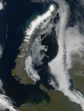
Severny Island ice cap is an ice cap on Severny Island, northern island of the Novaya Zemlya archipelago in Russia. It covers 40% of Severny Island (which is the 30th largest island in the world) at total area of about 20,500 km2 (7,900 sq mi) which makes it the largest glacier by area in Europe (if counted as part of it) easily beating second ranking Austfonna at 8,105 km2 (3,129 sq mi) and third ranking Vatnajökull at 8,100 km2 (3,100 sq mi).
Contents
- Map of Severny Island ice cap Arkhangelsk Oblast Russia
- Glaciers
- West coast
- East coast
- Other glaciers
- Nunataks
- References
Map of Severny Island ice cap, Arkhangelsk Oblast, Russia
Glaciers
A number of glaciers flow from the inner ice cap to Severny Island's coastline.
West coast
The following glaciers have their terminus on the coast of the Barents Sea.
East coast
The following glaciers have their terminus on the coast of the Kara Sea.
Other glaciers
Nunataks
Gora Severny Nunatak is a nunatak located in the northern section of the long ice cap not far from the western coast of the island. Further to the northeast there is another nunatak between the two outlets of the Bunge Glacier.