
Highest elevation 1,547 m (5,075 ft) Population 2,429 (2010) Operator Russia | Major islands 2 Area 90,650 km² | |
 | ||
Islands | ||
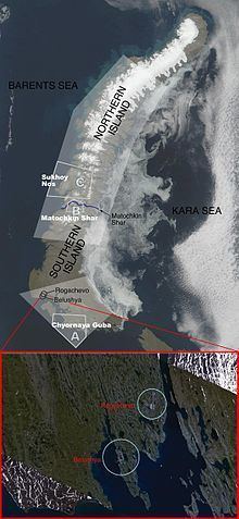
Novaya Zemlya (Russian: Но́вая Земля́; [ˈnovəjə zʲɪmˈlʲa], lit. new land), also known, especially in Dutch, as Nova Zembla, is an archipelago in the Arctic Ocean in northern Russia and the extreme northeast of Europe, the easternmost point of Europe lying at Cape Flissingsky on the Northern island. Administratively, it is incorporated as Novaya Zemlya District, one of the twenty-one in Arkhangelsk Oblast, Russia. Municipally, it is incorporated as Novaya Zemlya Urban Okrug.
Contents
Map of Novaya Zemlya, Arkhangelsk Oblast, Russia
Its population as of the 2010 Census was 2,429, of which 1,972 resided in Belushya Guba, an urban-type settlement that is the administrative center of Novaya Zemlya District. The population in 2002 was 2,716 (2002 Census). The indigenous population (from 1872 to the 1950s when it was resettled to the mainland) consisted of about 50–300 Nenetses who subsisted mainly on fishing, trapping, reindeer herding, polar bear hunting and seal hunting. Natural resources include copper, lead, and zinc.
Novaya Zemlya was a sensitive military area during the Cold War years and it is still used today. The Soviet Air Force maintained a presence at Rogachevo on the southern part of the island, on the westernmost peninsula (71.61787°N 52.47884°E / 71.61787; 52.47884). It was used primarily for interceptor aircraft operations but also provided logistical support for the nearby nuclear test area. Novaya Zemlya was the site of one of the two major nuclear test sites managed by the USSR, used for air drops and underground testing the largest of the Soviet nuclear bombs, in particular the October 30, 1961 air burst explosion of Tsar Bomba, the largest, most powerful nuclear weapon ever detonated.
Geography
Novaya Zemlya is an extension of the Northern part of the Ural Mountains, and the interior is mountainous throughout. It is separated from the mainland by the Kara Strait.
Novaya Zemlya consists of two major islands, separated by the narrow Matochkin Strait, as well as a number of smaller islands. The two main islands are:
The coast of Novaya Zemlya is very indented, and it is the area with the largest number of fjords in the Russian Federation.
Novaya Zemlya separates the Barents Sea from the Kara Sea. The total area is about 90,650 square kilometers (35,000 sq mi). The highest mountain is located on the Northern island and is 1,547 meters (5,075 ft) high.
Environment
The ecology of Novaya Zemlya is influenced by its severe climate, but the region nevertheless supports a diversity of biota. One of the most notable species present is the polar bear, whose population in the Barents Sea region is genetically distinct from other polar bear subpopulations.
History
The Russians knew of Novaya Zemlya from the 11th century, when hunters from Novgorod visited the area. For western Europeans, the search for the Northern Sea Route in the 16th century led to its exploration. The first visit from a west European was by Hugh Willoughby in 1553, and he met Russian ships from the already established hunting trade. Dutch explorer Willem Barentsz reached the west coast of Novaya Zemlya in 1594, and in a subsequent expedition of 1596 rounded the Northern point and wintered on the Northeast coast. (Barentsz died during the expedition, and may have been buried on the Northern island.) During a later voyage by Fyodor Litke in 1821–1824, the west coast was mapped. Henry Hudson was another explorer who passed through Novaya Zemlya while searching for the Northeast Passage.
The island was systematically surveyed by Pyotr Pakhtusov and Avgust Tsivolko in the early 1830s. The first permanent settlement was established in 1870 at Malye Karmakuly, which served as capital of Novaya Zemlya until 1924. Later the administrative center was transferred to Belushya Guba, in 1935 to Lagernoe, but then returned to Belushya Guba.
Small numbers of Nenets were resettled to Novaya Zemlya in the 1870s in a bid by Russia to keep out the Norwegians. This population, then numbering 298, was removed to the mainland in 1957 before nuclear testing began.
In 1943, during World War II, Novaya Zemlya briefly served as a secret seaplane base for the Nazis' Kriegsmarine, to provide German surveillance of Allied ships en route to Siberia. The seaplane base was established by U-255 and U-711, which were operating along the Northern coast of Soviet Russia as part of 13th U-boat Flotilla. Seaplane sorties were flown in August and September 1943.
Nuclear testing
In July 1954, Novaya Zemlya was designated the Novaya Zemlya Test Site, construction of which began in October and existed during much of the Cold War. "Zone A", Chyornaya Guba (70.7°N 54.6°E / 70.7; 54.6), was used in 1955–1962 and 1972–1975. "Zone B", Matochkin Shar (73.4°N 54.9°E / 73.4; 54.9), was used for underground tests in 1964–1990. "Zone C", Sukhoy Nos (73.7°N 54.0°E / 73.7; 54.0), was used in 1958–1961 and was the site of the 1961 Tsar Bomba test, the most powerful nuclear weapon ever detonated.
Other tests occurred elsewhere throughout the islands, with an official testing range covering over half of the landmass. In September 1961, two propelled thermonuclear warheads were launched from Vorkuta Sovetsky and Salekhard to target areas on Novaya Zemlya. The launch rocket was subsequently deployed to Cuba.
1963 saw the implementation of the Limited Test Ban Treaty which banned most atmospheric nuclear tests. The largest underground test in Novaya Zemlya took place on September 12, 1973, involving four nuclear devices of 4.2 megatons total yield. Although far smaller in blast power than the Tsar Bomba and other atmospheric tests, the confinement of the blasts underground led to pressures rivaling natural earthquakes. In the case of the September 12, 1973 test, a seismic magnitude of 6.97 on the Richter Scale was reached, setting off an 80 million ton avalanche that blocked two glacial streams and created a lake 2 kilometres (1.2 mi) in length.
Over its history as a nuclear test site, Novaya Zemlya hosted 224 nuclear detonations with a total explosive energy equivalent to 265 megatons of TNT. For comparison, all explosives used in World War II, including the detonations of two US nuclear bombs, amounted to only two megatons.
In 1988–1989, glasnost helped make the Novaya Zemlya testing activities public knowledge, and in 1990 Greenpeace activists staged a protest at the site. The last nuclear test explosion was in 1990 (also the last for the entire Soviet Union and Russia). The Ministry for Atomic Energy has performed a series of subcritical underwater nuclear experiments near Matochkin Shar each autumn since 1998. These tests reportedly involve up to 100 grams (3.5 oz) of weapons-grade plutonium.