
Highest point 383 metres (1,257 ft) | Total islands 5 + 3 rocks Area 7 km² | |
 | ||
Major islands Uotsuri-shima / Diaoyu DaoTaishō-tō / Chiwei YuKuba-shima / Huangwei YuKita-Kojima / Bei XiaodaoMinami-Kojima / Nan Xiaodao Islands Tobise, Okinominamiiwa Island, Okinokitaiwa Island | ||
China diaoyu islands v japan senkaku islands dispute same place
The Senkaku Islands (尖閣諸島, Senkaku-shotō, variants: 尖閣群島 Senkaku-guntō and 尖閣列島 Senkaku-rettō) are a group of uninhabited islands controlled by Japan in the East China Sea. They are located roughly due east of Mainland China, northeast of Taiwan, west of Okinawa Island, and north of the southwestern end of the Ryukyu Islands. They are also known as the Diaoyu Islands (Chinese: 钓鱼岛及其附属岛屿; pinyin: Diàoyúdǎo jí qí fùshǔ dǎoyǔ; also simply 钓鱼岛) in Mainland China, the Diaoyutai Islands (Chinese: 釣魚台列嶼; pinyin: Diàoyútái liè yǔ) in Taiwan, and the Pinnacle Islands.
Contents
- China diaoyu islands v japan senkaku islands dispute same place
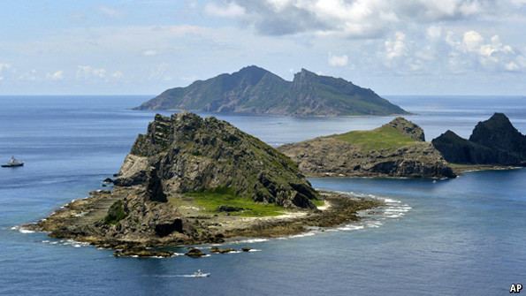
- Map of Senkaku Islands 2F Diaoyudao Islands 2F Diaoyutai Islands
- China s diaoyu senkaku islands air defense fun zone china uncensored
- Early history
- Control of the islands by Japan and the US
- Geography
- Flora and fauna
- Sovereignty dispute
- References
Map of Senkaku Islands %2F Diaoyudao Islands %2F Diaoyutai Islands
Following the discovery of potential undersea oil reserves in 1968 in the area and the 1971 transfer of administrative control of the islands from the United States to Japan, the latter's sovereignty over the territory is disputed by both the People's Republic of China (PRC) and the Republic of China (also known as Taiwan).
China claims the discovery and ownership of the islands from the 14th century, while Japan had ownership of the islands from 1895 until its surrender at the end of World War II. The United States administered the islands as part of the United States Civil Administration of the Ryukyu Islands from 1945 until 1972, when the islands returned to Japanese control under the Okinawa Reversion Agreement between the United States and Japan.
The islands are disputed between China and Japan and between Japan and Taiwan. Despite the diplomatic stalemate between China and Taiwan, both governments agree that the islands are part of Taiwan as part of Toucheng Township in Yilan County. Japan regards the islands as a part of the city of Ishigaki in Okinawa Prefecture, and acknowledges the claims of neither China nor Taiwan but has not allowed the Ishigaki administration to develop the islands.
China s diaoyu senkaku islands air defense fun zone china uncensored
Early history
Records of these islands date back to as early as the 15th century when they were referred as Diaoyu in books such as Voyage with a Tail Wind (simplified Chinese: 顺风相送; traditional Chinese: 順風相送; pinyin: Shùnfēng Xiāngsòng) (1403) and Record of the Imperial Envoy's Visit to Ryūkyū (simplified Chinese: 使琉球录; traditional Chinese: 使琉球錄; pinyin: Shĭ Liúqiú Lù) (1534). Adopted by the Chinese Imperial Map of the Ming Dynasty, the Chinese name for the island group (Diaoyu) and the Japanese name for the main island (Uotsuri) both mean "fishing".
Historically, the Chinese had used the uninhabited islands as navigational markers in making the voyage to the Ryukyu Kingdom upon commencement of diplomatic missions to the kingdom, "resetting the compass at a particular isle in order to reach the next one".
The first published description of the islands in Europe appears in a book imported by Isaac Titsingh in 1796. His small library of Japanese books included Sangoku Tsūran Zusetsu (三国通覧図説, An Illustrated Description of Three Countries) by Hayashi Shihei. This text, which was published in Japan in 1785, described the Ryūkyū Kingdom. Hayashi followed convention in giving the islands their Chinese names in his map in the text, where he coloured them in the same pink as China.
In 1832, the Oriental Translation Fund of Great Britain and Ireland supported the posthumous abridged publication of Titsingh's French translation.
The name, "Pinnacle Isles" was first used by James Colnett, who charted them during his 1789-1791 voyage in the Argonaut. William Robert Broughton sailed past them in November 1797 during his voyage of discovery to the North Pacific in HMS Providence, and referred to Uotsuri Island as "Peaks Island". Reference was made to the islands in Edward Belcher's 1848 account of the voyages of HMS Sammarang. Captain Belcher observed that "the names assigned in this region have been too hastily admitted." Belcher reported anchoring off Pinnacle Island in March 1845.
In the 1870s and 1880s, the English name Pinnacle Islands was used by the British navy for the rocks adjacent to the largest island Uotsuri-shima / Diaoyu Dao (then called 和平嶼 hô-pîng-sū, "Peace Island" in Hokkien); Kuba-shima / Huangwei Yu (then called Ti-a-usu); and Taishō-tō / Chiwei Yu.
A Japanese navy record issued in 1886 first started to identify the islets using equivalents of the Chinese and English terms employed by the British. The name "Senkaku Retto" is not found in any Japanese historical document before 1900 (the term "Senkaku Gunto" began being used in the late 19th century), and first appeared in print in a geography journal published in 1900. It was derived from a translation of the English name Pinnacle Islands into a Sinicized Japanese term "Sento Shoto" (as opposed to "Senkaku Retto", i.e., the term used by the Japanese today), which has the same meaning.
The collective use of the name "Diaoyutai" to denote the entire group began with the advent of the controversy in the 1970s.
Control of the islands by Japan and the US
As the uninhabited islets were historically used as maritime navigational markers, they were never subjected to administrative control other than the recording of the geographical positions on maps, descriptions in official records of Chinese missions to the Ryukyu Kingdom, etc.
The Japanese central government annexed the islands in early 1895 after emerging victorious from the First Sino-Japanese War. Around 1900, Japanese entrepreneur Koga Tatsushirō (古賀 辰四郎) constructed a bonito fish processing plant on the islands, employing over 200 workers. The business failed around 1940 and the islands have remained deserted ever since. In the 1970s, Koga Tatsushirō's son Zenji Koga and Zenji's wife Hanako sold four islets to the Kurihara family of Saitama Prefecture. Kunioki Kurihara owned Uotsuri, Kita-Kojima, and Minami-Kojima. Kunioki's sister owns Kuba.
The islands came under US government occupation in 1945 after the surrender of Japan ended World War II. In 1969, the United Nations Economic Commission for Asia and the Far East (ECAFE) identified potential oil and gas reserves in the vicinity of the Senkaku Islands. In 1971, the Okinawa Reversion Treaty passed the U.S. Senate, returning the islands to Japanese control in 1972. Also in 1972, the Republic of China (Taiwan) government and People's Republic of China government officially began to declare ownership of the islands.
Since 1972, when the islands reverted to Japanese government control, the mayor of Ishigaki has been given civic authority over the territory. The Japanese central government, however, has prohibited Ishigaki from surveying or developing the islands. In 1979 an official delegation from the Japanese government composed of 50 academics, government officials from the Foreign and Transport ministries, officials from the now-defunct Okinawa Development Agency, and Hiroyuki Kurihara, visited the islands and camped on Uotsuri for about four weeks. The delegation surveyed the local ecosystem, finding moles and sheep, studied the local marine life, and examined whether the islands would support human habitation.
From 2002 to 2012, the Ministry of Internal Affairs and Communications paid the Kurihara family ¥25 million a year to rent Uotsuri, Minami-Kojima and Kita-Kojima. Japan's Ministry of Defense rents Kuba island for an undisclosed amount. Kuba is used by the U.S. military as a practice aircraft bombing range. Japan's central government completely owns Taisho island.
On December 17, 2010, Ishigaki declared January 14 as "Pioneering Day" to commemorate Japan's 1895 annexation of the Senkaku Islands. China condemned Ishigaki's actions. In 2012, both the Tokyo Metropolitan and Japanese central governments announced plans to negotiate purchase of Uotsuri, Kita-Kojima, and Minami-Kojima from the Kurihara family.
On September 11, 2012, the Japanese government nationalized its control over Minami-kojima, Kita-kojima, and Uotsuri islands by purchasing them from the Kurihara family for ¥2.05 billion. China's Foreign Ministry objected saying Beijing would not "sit back and watch its territorial sovereignty violated."
In 2014, Japan constructed a lighthouse and wharf featuring Japanese flag insignia on the islets.
Geography
The island group are known to consist of five uninhabited islets and three barren rocks. China has identified and named as many as 71 islets that belong to this group after the Japanese Cabinet released names of 39 uninhabited islands.
These minor features in the East China Sea are located approximately 120 nautical miles northeast of Taiwan, 200 nautical miles east of the Chinese mainland and 200 nautical miles southwest of the Japanese island of Okinawa.
In ascending order of distances, the island cluster is located:
The depth of the surrounding waters of the continental shelf is approximately 100–150 metres (330–490 ft) except for the Okinawa Trough on the south.
The existence of the back-arc basin complicates descriptive issues. According to Professor Ji Guoxing of the Asia-Pacific Department at Shanghai Institute for International Studies,
Flora and fauna
Permission for collecting herbs on three of the islands was recorded in an Imperial Chinese edict of 1893.
Uotsuri-shima, the largest island, has a number of endemic species such as the Senkaku mole (Mogera uchidai) and Okinawa-kuro-oo-ari ant. Due to the introduction of domestic goats to the island in 1978, the Senkaku mole is now an endangered species.
Albatross are observed in the islands. Amongst all islands, Minami Kojima is one of the few breeding places of the rare short-tailed albatross (Phoebastria albatrus).
Rich marine biodiversity adjacent to the islands have been regarded but have been poorly studied. Seemingly, varieties of larger fish and animals inhabit or migrate through the area, including tunas, sharks, marlins, critically endangered hawksbill sea turtles, dolphins, pilot whales, sperm whales, and humpback whales.
Sovereignty dispute
Territorial sovereignty over the islands and the maritime boundaries around them are disputed between the People's Republic of China, the Republic of China (Taiwan), and Japan.
The People's Republic and Taiwan claim that the islands have been a part of Chinese territory since at least 1534. They acknowledge that Japan took control of the islands in 1894–1895 during the first Sino-Japanese War, through the signature of the Treaty of Shimonoseki. They assert that the Potsdam Declaration (which Japan accepted as part of the San Francisco Peace Treaty) required that Japan relinquish control of all islands except for "the islands of Honshū, Hokkaidō, Kyūshū, Shikoku and such minor islands as we determine", and they state that this means control of the islands should pass to China.
Japan does not accept that there is a dispute, asserting that the islands are an integral part of Japan. Japan has rejected claims that the islands were under China's control prior to 1895, and that these islands were contemplated by the Potsdam Declaration or affected by the San Francisco Peace Treaty.
In 2012 Japanese Ministry of Foreign Affairs created a website in support of its claims, In late 2014 National Marine Data and Information Service, a department under the State Oceanic Administration of People's Republic of China created a website of its own to support its claims. In 2016, Chinese fishing, Coast Guard and other vessels were entering the territorial waters around the islands almost daily and in August 2016 the Japanese foreign minister Fumio Kishida told China’s foreign minister Wang Yi "that the activity represented an escalation of tensions" according to Japanese sources. It was the first meeting of the top diplomats since the Permanent Court of Arbitration ruling against China's South China Sea claims and was coincident with a three-party meeting (including South Korea) relative to a North Korean submarine-launched missile in the Sea of Japan.