
Surface area 827 acres (3.35 km) Area 3.347 km² Mean depth 14 m | Primary inflows Max depth 34 m Surface elevation 85 m Outflow location Saugatuck River | |
 | ||
Catchment area 35 square miles (91 km) Similar Quinebaug Lake State Park, Trout Brook Valley State Par, Stillwater Pond State Park, Devil's Den Preserve, Lillinonah Trail | ||
Saugatuck reservoir crappie bass trout
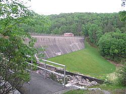
The Saugatuck Reservoir is a reservoir in Fairfield County, Connecticut, US, that straddles the border between the towns of Redding and Weston. It is created by the Samuel P. Senior dam of the Saugatuck River, and provides water to several of the surrounding towns. It is considered quite scenic and is stocked with trout for fishing. It borders the Trout Brook Valley State Park Reserve at the southeast.
Contents
Map of Saugatuck Reservoir, Connecticut, USA
Bridgeport Hydraulic Company Holdings (now owned by Aquarion) flooded the Saugatuck River Valley after 1938 displacing the village of Valley Forge to create the Saugatuck Reservoir.
Aquarion Water Co., owner of the reservoir and dam, allows tailrace fishing in one area at the Weston end of the reservoir, where it has constructed a handicapped-access area. However, anglers must obtain a permit from Aquarion before fishing in the Saugatuck.
The Saugatuck is the largest of the eight reservoirs that make up Aquarion’s greater Bridgeport water system. It holds about 12 billion US gallons (45,000,000 m3) of water.
The following fish species may be found within the Saugatuck Reservoir:
American eelBluegill (Sunfish)Brook troutBrown troutBullhead catfishChain pickerelCrappieLargemouth bassPumpkinseed (Sunfish)Rainbow troutRock bassSmallmouth bassWalleyeWhite perchYellow perch