
Country United States NECTA Bridgeport-Stamford Incorporated 1787 Elevation 96 m Population 10,179 (2010) | Region South Western Region Time zone Eastern (UTC-5) Zip code 06883 Local time Saturday 8:45 AM | |
 | ||
Weather 2°C, Wind N at 26 km/h, 88% Humidity | ||
Weston is a town in Fairfield County, Connecticut. The population was 10,179 at the 2010 census. The town is served by Route 57 and Route 53, both of which run through the town center. About 19% of the town's workforce commutes to New York City, about 45 miles (72 km) to the southwest.
Contents
- Map of Weston CT 06883 USA
- History
- Geography
- Principal communities
- Demographics
- Government
- Budget and taxes
- On the National Register of Historic Places
- Education
- Parks
- Notable people
- References
Map of Weston, CT 06883, USA
Like many towns in southwestern Connecticut, Weston is among the most affluent communities in the United States. Data collected in 2011 showed that Weston had the highest median household income in Fairfield County, Connecticut, at US$205,173.
In 2011 Connecticut Magazine named Weston as the number one town in Connecticut among towns with populations of 10,000–15,000. The rating considers education, crime, economy, cost and leisure.
Weston is bordered by Wilton to the west, Redding to the north, Easton to the east, Fairfield to the southeast, and Westport to the south.
Aside from a handful of stores that form the town’s center, Weston has little commercial development. Residential development is limited by two-acre zoning. Most of Devil's Den Preserve, a 1,746-acre (707 ha) nature reserve, which gets 40,000 visits a year, is located in the town.
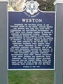
History
In the 17th century, Weston's first English settlers were mostly farmers living in the town of Fairfield, Connecticut, the boundaries of which extended to Weston until the late 18th century. The Norfield Parish was created in the area now occupied by the towns of Weston and Easton. In 1787, the area was formally incorporated as the Town of Weston. In 1845, the Town of Easton was split off from Weston.
A meteor exploded above the town December 14, 1807. Six pieces, totaling 28 pounds (13 kg), were recovered and examined by scientists, who issued a report. This was the first time that people realized the nature of meteors.
Despite rocky soil, farmers in town grew apples, onions, and potatoes. Grist, cider, lumber, and fulling mills were built. The town had nine manufacturers by 1850, but two decades later only the Bradley Edge Tool Company still thrived. That factory burned down in 1911.
Unlike other nearby towns, Weston never had a railroad built through it, which stifled the development of non-agricultural businesses. Between the Civil War and the Great Depression, the town's population dropped from approximately 1,000 to a low of 670, by 1930. Artists, writers, and actors from New York became attracted to the community in the 1930s and began settling in it. Construction of the Merritt Parkway, which arrived to the south of Weston in 1938, resulted in further population growth.
Geography
According to the United States Census Bureau, the town has a total area of 20.7 square miles (54 km2), of which 19.8 square miles (51 km2) is land and 0.9 square miles (2.3 km2), or 4.39%, is water.
The Saugatuck River begins to the north in Redding. It flows through the town and ends in Long Island Sound in neighboring Westport.
Weston is bordered by Westport to the south, Wilton to the west, Redding to the north, Easton to the east, and Fairfield to the southeast.
Principal communities
Other minor communities and geographic areas are Devil's Den, Norfield, Upper Parish, and Valley Forge.
Demographics
As of the census of 2010, there were 10,025 people, 3,289 households, and 2,811 families residing in the town. The population density was 506.0 people per square mile (195.7/km²). There were 3,629 housing units at an average density of 178.4 per square mile (68.9/km²). The racial makeup of the town was 95.75% White, 0.88% African American, 0.11% Native American, 1.94% Asian, 0.10% Pacific Islander, 0.25% from other races, and 0.98% from two or more races. Hispanic or Latino of any race were 2.05% of the population.
There were 3,289 households out of which 49.8% had children under the age of 18 living with them, 78.4% were married couples living together, 5.0% had a female householder with no husband present, and 15.1% were non-families. 11.2% of all households were made up of individuals and 4.9% had someone living alone who was 65 years of age or older. The average household size was 3.03 and the average family size was 3.28.
In the town, the population was spread out with 31% under the age of 18, 4% from 18 to 24, 31% from 25 to 49, 23% from 50 to 64, and 11% who were 65 years of age or older. The median age was 42 years. For every 100 females there were 96.5 males. For every 100 females age 18 and over, there were 92.9 males.
The median income for a household in the town was $209,630. Males had a median income of $220,357 versus $95,455 for females. The per capita income for the town was $92,375. About 1.5% of the population were below the poverty line.
Government
Like many other New England towns, the government of Weston consists of the Town Meeting, and elective and appointive boards. First among the elective boards is the Board of Selectmen. Nina Daniel is the First Selectman. By charter, the First Selectman is the Chief Executive and Administrative Officer of the town. The town's legislative powers are divided between the Board of Selectmen and the Town Meeting. Among other elective boards are the Board of Education, the Board of Finance, the Planning and Zoning Commission, and the Board of Police Commissioners.
Budget and taxes
For the fiscal year of 2014–2015, the Town of Weston’s gross budget is about $67-million. About 70 percent of the town’s budget is spent on the Weston Public Schools. Weston raises taxes on the basis of property value. With real estate assessed at 70 percent of market value, the mill rate evolved as follows:
To show the evolution of the mill rate, the asterisked numbers are adjusted to account for the revaluation of 2013-2014. The revaluation decreased the real estate property values by 13.18 percent, not counting a 0.75 percent natural growth in real estate stock during the revaluation. Besides, the numbers for 2008–2009 and prior years are further adjusted for the 2008-2009 revaluation which added 2.92 percent to Weston's grand list of properties.
On the National Register of Historic Places
Education
There are four public schools in the Weston Public Schools district, all located on School Road:
In June 2012, 24/7 Wall St. ranked Weston as the second wealthiest school district in the United States.
In May 2013, and again in 2014 U.S. News & World Report ranked Weston High School as the third best high school in the state and 240th best high school in the country out of more than 22,000 high schools assessed throughout the country including public and private. Weston High School was awarded the Gold medal for its high level of student performance. The methodology of ranking the high schools is based on student performance on standardized tests as well as student participation in Advanced Placement (AP) or International Baccalaureate (IB) programs. The AP exam participation rate is 60% of Weston High School students.
In August 2015, Newsweek ranked Weston High School #47 for America's Top High Schools in the country, public and private.
In Aug 2015, Weston High School was ranked the best in the state and 47th best in the country according to a survey conducted by Newsweek magazine. Each year, the magazine ranks the top 500 high schools in the country based on which institutions do the best job of preparing students for college. According to the study, Weston High School has a 97.2% college enrollment rate, a 100% graduation rate, an AP/IB/Dual Enrollment Composite of 73, a weighted SAT/ACT score composite of 69.4, a student retention rate of 91.7% and a counselor-to-student ratio of 1:156. In addition, the average SAT score at Weston High School is 1784, the average ACT score is 26.6, and the average AP test score is 3.87. [
The Connecticut State Department of Education has ranked the Weston schools in District Reference Group A (formerly the Educational Reference Group A), the nine most affluent and low-need-for-extra-assistance districts among the 162 school districts in Connecticut.
Several pre-schools in town are run by various churches, including Emmanuel Nursery School and Norfield Nursery School.
Parks
The landscape of Weston is characterized by open spaces. Almost one quarter of the town is permanently devoted to open space use, including: