
Population 260 (2010) | Zone Lumbini Zone Area code -75 | |
 | ||
Satpokharee is a valley in the V.D.C.Gothadi ward no. 2 Palpa District in the Lumbini Zone of southern Nepal. Population of 260 people living in 52 individual households.
Contents
Geography
Satpokharee is 25.6 km south-east of the headquarters city Tansen. The valley is bounded by Rahabas V.D.C. in the east, Gothadi in the south and Jhadewa V.D.C. in the north. The popular River Jhumsa khola connects with the Thadekhola (Rahabskhola) orgn.source started in northern part.
Development
Ncell the country’s largest private GSM mobile service provider, Ncell & other GSM mobile service provider multiple company has installed mobile tower using a solar power to operate its Base Transceiver Station (BTS) towers under its ‘Going Green’ scheme on 1 years ago at Nyaurikot Hill (Rehadi-Kerauli Jhadewa) north-east of valley. Now approximately 90% peoples are using a cellphone in the valley. even farmers & housewife....engaged in mobile!!!. yes we can say that valley is going through changes.....
Tourism
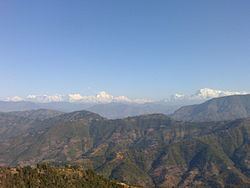
The village is top of the hills on all sides.the view of mountain Dhaulagiri and Annapurna has added more beauty to Satpokharee. The tourism industry has not yet been developed because of the lack of resources.