
Parent peak K2 Easiest route Northeast ridge Highest point Dhaulagiri I | Parent range Dhaulagiri Himal Elevation 8,167 m Range Himalayas | |
 | ||
Prominence 3,357 m (11,014 ft) Ranked 55th Isolation 318 kilometres (198 mi) First ascent May 13, 1960 by Kurt Diemberger, A. Schelbert, E. Forrer, Nawang Dorje, Nyima Dorje(First winter ascent 21 January 1985 Jerzy Kukuczka and Andrzej Czok) Mountains Dhaulagiri I, Dhaulagiri II Similar | ||
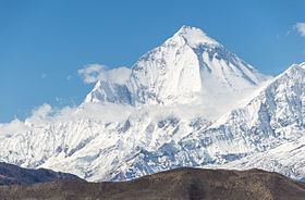
The Dhaulagiri massif in Nepal extends 120 km (70 mi) from the Kaligandaki River west to the Bheri. This massif is bounded on the north and southwest by tributaries of the Bheri River and on the southeast by Myagdi Khola. Dhaulagiri I is the seventh highest mountain in the world at 8,167 metres (26,795 ft) above sea level. It was first climbed on May 13, 1960 by a Swiss/Austrian/Nepali expedition.
Contents
- Map of Dhaulagiri Mudi 33200 Nepal
- Geography
- Dhaulagiri I climbing history
- Partial timeline
- Other peaks in the Dhaulagiri Himalaya
- Climbing history
- References
Map of Dhaulagiri, Mudi 33200, Nepal
The mountain's name is धौलागिरी (dhaulāgirī) in Nepali. This comes from Sanskrit where धवल (dhawala) means dazzling, white, beautiful and गिरि (giri) means mountain. Dhaulagiri I is also the highest point of the Gandaki river basin.
Annapurna I (8,091m/26,545 ft) is 34 km. east of Dhaulagiri I. The Kali Gandaki River flows between the two in the Kaligandaki Gorge, said to be the world's deepest. The town of Pokhara is south of the Annapurnas, an important regional center and the gateway for climbers and trekkers visiting both ranges as well as a tourist destination in its own right.
Geography
Looking north from the plains of India, most 8,000-metre peaks are obscured by nearer mountains, but in clear weather Dhaulagiri I is conspicuous from northern Bihar and as far south as Gorakhpur in Uttar Pradesh. In 1808 A.D. survey computations showed it to be the highest mountain yet surveyed. This lasted until 1838 when Kangchenjunga took its place, followed by Mount Everest in 1858.
Dhaulagiri I's sudden rise from lower terrain is almost unequaled. It rises 7,000 m (22,970 ft) from the Kali Gandaki River 30 km to the southeast. The south and west faces rise precipitously over 4,000 m (13,120 ft). The south face of Gurja Himal in the same massif is also notably immense.
Dhaulagiri I climbing history
Most ascents have followed the northeast ridge route of the first ascent, but climbs have been made from most directions. As of 2007 there had been 358 successful ascents and 58 fatalities. Between 1950 and 2006, 2.88% of 2,016 expedition members and staff going above base camp on Dhaulagiri I died. On all 8,000 metre peaks in Nepal the death rate was 1.63%, ranging from 0.65% on Cho Oyu to 4.04% on Annapurna I and 3.05% on Manaslu.
Partial timeline
Other peaks in the Dhaulagiri Himalaya
† Only peaks above 7,200 m with more than 500 m (1,640.4 ft) of topographic prominence are ranked.
‡ The status of Churen Himal's three peaks is unclear and sources differ on their heights. The coordinates, heights and prominence values above are derived from the Finnmap. The first ascent data is from Neate, but it is unclear if the first ascent of Churen Himal East was actually an ascent of the highest of the three peaks, as Neate lists Churen Himal Central as a 7,320 m subpeak of Churen Himal East.
Most of the named 7,000 metre peaks are on a ridge extending WNW, separated from Dhaulagiri I by 5,355m French Pass at 28°46'55"N, 83°31'54"E. In order they are Dhaulagiri II, III, V, IV, Junction Peak, Churens East, Central and West, Putha Hiunchuli and Hiunchuli Patan. False Junction Peak, Dhaulagiri VI and Gurja are on a ridge extending south from Junction Peak. The British Alpine Club's Himalayan Index lists 37 more peaks over 6,000 m.
6,182m Pota Himal (FinnMap sheet 2883-01 "Chhedhul Gumba") stands north of the main ridge between Churen and Putha Hiunchuli. Pota has been informally renamed Peak Hawley after Elizabeth Hawley, a notable expedition chronicler and Kathmandu-based reporter.
Hiunchuli Patan at the western end nearest the Bheri River is locally called Sisne or Murkatta Himal. It was an iconic landmark to insurgents based in Rukum and Rolpa districts during the 1996-2006 Nepal Civil War.
Climbing history
- Pre-monsoon and post-monsoon reconnaissances of Dh.II by Japanese expeditions.
- Hangde 6556m in Mukut section attempted.
- Churen attempt from north by Japanese Nihon University expedition. Climbed Hangde (~6600m), Tongu (~6250m), P6265 during approach/acclimation through Hidden Valley; also Kantokal (~6500m) north of Putha Hiunchili.
- Churen and Dh.VI attempt from south by J. O. M. Roberts, thinking he was on Dh.IV due to inaccurate maps. Climbed a lower peak (6,529m) near Gurja, naming it Ghustang after the stream draining the cirque they climbed in.
- Dh.II attempt by Austrian expedition, reaching 7,000m
- Dh.III attempt
- Japanese expedition to Dh.II delayed two months by heavy snow in approach passes. Lost two porters to avalanche, then another porter was injured in a fall and needed evacuation. This left too little food to continue.
- J. O. M. Roberts leads British R.A.F. expedition to Dh.VI, still believing it was Dh.IV. Defeated by late monsoon, then early winter storms creating excessive avalanche risk.
- Dh.IV attempt by Austrian Alpine Club. Five Austrians and one Nepali disappear, may have summited.
- Gurja climbed by Japanese expedition.
- First authorized ascents of Tukuche 6920m and Tukuche West 6800m.
- Japan's Kansai Mountaineering Club unsuccessful on Dh.IV in April but climbed Dh.VI and False Junction Peak.
- Korean expedition claims they summited Churen East on April 29. Questioned by same year Japanese expedition, see next.
- Japanese expedition climbs Churen Central and Churen West on October 24.
- First ascent of Dh.II on May 18 by German expedition.
- Dh.IV attempt
- Dh.V attempted by pre- and post-monsoon Japanese expeditions. Both ended by fatal accidents.
- first ascent of Dh.III on October 20 by German expedition.
- Dh.IV attempted by Austrians who reached 7250m on N face, then by British who quit after two deaths.
- Dh.IV attempt by British R.A.F. expedition abandoned after three Sherpas killed by falling ice.
- In Mukut section: ascents of Parbat Rinchen 6200m, Parbat Talpari 6248m, West Himparkhal 6248m, East Himparkhal 6227m, Tashi Kang III 6157m
- Dh.IV climbed May 9 by S. Kawazu and E. Yusuda, who died on descent, bringing death toll on Dh.IV to 14. (Compared with 13 deaths on Mount Everest before it was successfully climbed in 1953.) Another Japanese expedition in October puts ten on summit without loss of life.
- Dh.V climbed by M. Morioka and Pembu Tsering Sherpa on Japanese expedition.