
 | ||
Saskatchewan River fur trade The Saskatchewan River was one of the two main axes of Canadian expansion west of Lake Winnipeg. The other and more important one was northwest to the Athabasca Country. For background see Canadian canoe routes (early).
Contents
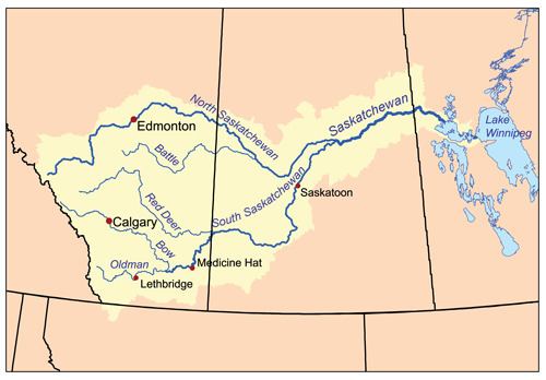
The main trade route followed the North Saskatchewan River and Saskatchewan River, which were just south of the forested beaver country. The South Saskatchewan River was a prairie river with few furs.
The Saskatchewan River was a natural highway for furs going east and trade goods going west. The forests to the north provided beaver pelts. The grassland to the south provided buffalo for food and pemmican to feed to voyageurs in the food-poor country to the north. Pemmican was often more important than beaver. Most was sent downriver to Cumberland House, Saskatchewan, before being sent northward, but from 1790 some was sent via a relatively short overland route to the Green Lake, Saskatchewan and on to the Athabasca Country.
The Saskatchewan has no significant portages between the rapids at Rocky Mountain House and its mouth at Lake Winnipeg. Eastbound canoes with that winter's catch had the advantage of the spring meltwater. Westbound trade goods in the summer and fall had to deal with low water and there was significant use of poling and tracking on the upper river. The Hudson's Bay Company built the first proto-York boat on the river at Manchester House in 1788, but the North West Company seems to have preferred north canoes. In the La Montee country west of Prince Albert, "bosses" would borrow horses and go buffalo hunting to feed the regular voyageurs who had to stay in their canoes and continue rowing upstream. When speed was required one could ride horseback parallel to the river. Around 1825 a horse track was cut from Fort Assiniboine, Alberta on the Athabasca River to Edmonton. (The easiest route from the Pacific through Athabasca Pass to the Athabasca River. The shortcut meant a straighter route and the use of York boats. The Athabasca River route was indirect and required smaller north canoes for the numerous portages.) From the 1870s the slaughter of buffalo, smallpox and the appearance of settlers disrupted Indian life. In 1876 an ox-cart road was built from Fort Carlton north to Green Lake. The first steamboat on the river was the Northcote in 1874. The Carlton Trail evolved to connect Winnipeg to Edmonton. In 1905 the Canadian Northern Railway reached Edmonton from Winnipeg.
The boreal forest region to the north was inhabited by Cree who had migrated northwest as middlemen in the fur trade and, in the early and middle 19th. century, Saulteaux. Immediately south were the Plains Cree and Assiniboines with the Nakoda (Stoney) near the mountains. To the south were the Gens du large or Plains Indians: Gros Ventre in Saskatchewan, Blackfeet in Alberta and Piegan Blackfeet near the Rocky Mountains. Across the mountains were Kootenays. Since the Cree and Saulteaux had beaver to trade and the plains Indians had little more than buffalo and wolf skins, the northern tribes got most of the guns. They used them to expand south. This made the plains Indians hostile to the traders since they seemed to be allies of the more northern tribes. Further, many of the voyageurs were part-Cree and knew the language. The trading posts were too well fortified to be easily attacked and were only destroyed when the traders were away. The only exception was Fort Pitt in 1885 which no longer had a stockade. In the east the Gros Ventres destroyed South Branch House and Manchester House in 1793/94. In the west the Blackfeet were always threatening, avoided trading where there were many Cree and tried to keep the Kootenays from getting guns. Fort Sturgeon was burnt in 1780 and Rocky Mountain House in 1860. Fort Pitt and Fort Carlton were burnt during the North West Rebellion in 1885.
Exploration
Map and table
Most of the posts lasted less than ten years because the area became depleted of beaver and because the wooden stockades tended to rot. The major or permanent posts on the North Saskatchewan River were Cumberland House, Fort Pitt, Fort Carlton, Edmonton and Rocky Mountain House. Especially in the east there were a number of minor temporary posts that left few or no records. Until 1811, fur traders affiliated with the NWC and HBC maintained very amicable relations to the extent that the rival posts were often enclosed within the same palisades for mutual protections. After 1811, however, competition between the HBC and the NWC became increasingly intense (Blondal et al. 2008). .
In the table below locations are given by longitude and approximate straight-line distance from the post or landmark to the east. The straight-line distance from Lake Winnipeg to Howse pass is about 1,200 km or 750 miles. For Pedlars see Pedlar (fur trade). For the XY Company see North West Company#Organizational history.