
South end: Hwy 18 Length 129 km | Major cities: no cities on route | |
 | ||
Ruralmunicipalities: | ||
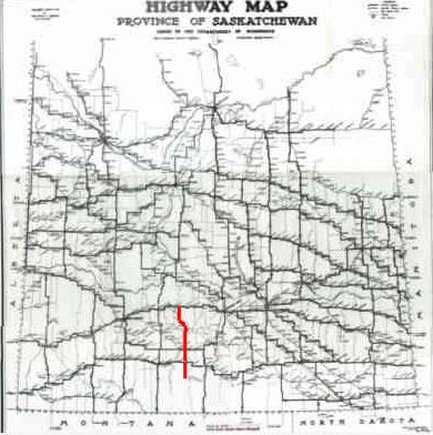
Saskatchewan highway 58
Highway 58 is an oiled surface highway in the Canadian province of Saskatchewan which handles approximately 100 vehicles per day. It runs from Highway 18 3 kilometers west of Fir Mountain until Highway 1/Highway 19 near Chaplin in the South-Central area of the province. Highway 58 is about 132 kilometers (82 mi.) long traversing through the Missouri Coteau. There is one multiplex of 5 kilometers with Saskatchewan Highway 363.
Contents
- Saskatchewan highway 58
- Flood water runs over transcanada highway in saskatchewan
- Communities
- History
- Attractions
- References
The highway's passage through the province offers a diverse sample of Saskatchewan to a traveler, taking in rural villages and towns, the scenery of the Missouri Coteau, Thomson Lake which is a man made lake for recreational and reservoir purposes, natural lakes such as Chaplin Lake which is the second largest saline lake in Canada. The terrain of the Missouri Coteau features low hummocky, undulating, rolling hills, potholes, and grasslands. This physiographic region of Saskatchewan is the uplands Missouri Coteau, a part of the Great Plains Province or Alberta Plateau Region which extends across the south east corner of the province of Saskatchewan. Highway 58 runs through the first regional park of Saskatchewan; Thomson Lake Regional Park, and also provides nearby access to Shamrock Regional Park another early regional park of Saskatchewan. The Louis Pierre Gravel National Historic Marker commemorates history at the north end of Highway 58, and the Cripple Creek Provincial Historic Marker is located at the south end. Highway 58 also penetrates into the heart of south central Saskatchewan to access the Chaplin/Old Wives/ Reed Lakes Complex, a shorebird sanctuary of international repute and fame.
Flood water runs over transcanada highway in saskatchewan
Communities
Wood Mountain First Nations Reserve is located near Fir Mountain and is south of the southern terminus of Highway 58. Historically Sioux Indians traversed this area as they followed Sitting Bull. 37.2 kilometers north is Lafleche, Saskatchewan first called Buffalo Head. Lafleche is located near Thomson Lake and became a town in 1953. The CPR line came through, in 1913. Mail delivery arrived via train, however this switched to mail truck in 1958. Traveling a distance of 57.8 kilometers is the town of Gravelbourg which is noted for being the Cultural Gem of Saskatchewan. Gravelbourg features the Our Lady of Assumption Roman Catholic Co-Cathedral and at one time was a bustling agricultural centre and hosted nine agricultural elevators. Shamrock Regional Park is south east of Shamrock, Saskatchewan. 98.5 kilometers from the southern terminus is the village of Shamrock. Traveling 135 kilometers to the northern terminus of Highway 58 is Chaplin. A major attraction for bird watchers is the Chaplin Shorebird Site. Approaching this town, there is a large American avocet statue beside the road in tribute to the many bird watching sanctuaries. Chaplin is home to diverse industry such as a shrimp processing plant, sodium sulphate mining and pulse and oilseed agriculture.
History
The rural municipalities were created to provide a civic government to rural residents, such as police, health, and fire protection, education, as well as bridge and road maintenance and construction. The early roads in Saskatchewan began as dirt roads along the township and range roads surveyed by the Dominion Government land surveyors around homestead allotments. 2 and 4 horse teams would plow and grade these roads before graders and scrapers were bought by the various rural municipalities. The RM would also hire crews to maintain the road ditches, and keep the roads clear of snow during the winter months. Joint funding with the provincial government and RMs provided oil surfacing and ashpalt highway surfaces.
Waverley RM was honored to have Boyd Anderson as their Rural Municipality reeve for 27 years. He has been honoured with a number of awards among them are the Northern International Livestock Hall of Fame, Saskatchewan Agricultural Hall of Fame, honorary doctor of laws degree and Centennial Medal. Waverly RM serves 422 rural residents (2006 census) since its incorporation on February 1, 1913. within an area of 1,429.30 kilometers squared.
Wood River RM was incorporated December 9, 1912. This RM provides essential services to 387 rural residents (2006 census) within its area of 838.45 kilometers squared.
Gravelbourg RM in 1928 was the most populated Rural Municipality in Saskatchewan. In 2006 this RM served 329 rural residents within 842.08 kilometers squared. Gravelbourg RM was established December 9, 1912.
Shamrock RM was created August 26, 1912, and encompasses two rural villages, Shamrock on the highway as well as Kelstern which is nearby. The main economic activity is livestock and crop production. Shamrock RM serves 226 rural residents(2006 census) within its boundaries contained in an area of 757.52 kilometers squared.
Chaplin RM covers a total area of 802.74 kilometers squared and a population of 138 as of 2006 and was incorporated on January 1, 1913. The Rural Municipality serves the rural community with various infrastructure requirements.
Attractions
National Historic Site, Louis Pierre Gravel honours the arrival of the abbot Louis-Pierre Gravel, a missionary-colonizer and the Franco-Americans who settled Gravelbourg. The memorial site is located south of Highway 43 and just east of Highway 58.
Thomson Lake Regional Park a man made lake along Highway 58 near Lafleche, Saskatchewan is 81 hectares (200 acres) in size and hosts swimming lessons, camping, picnicking, boating and golf. Thomson Lake was created in 1958 by Dr Thomson as a reservoir for Lafleche and Gravelbourg creating water resources in the dry desert like area historically known as the Palliser Triangle. Thomson Lake local regional park became the first regional park in the province of Saskatchewan.
Notukeu Creek is traversed by Highway 58.
Shamrock Regional Park is 55 acres (220,000 m2) in size and features camping, a playground, and baseball diamonds on the Wood River.
Chaplin Lake is a saline lake which has an area of 52 kilometers squared (20 mi2), making it the second largest saline lake in Canada. is a haven for many varieties of shorebirds. The Chaplin, Old Wives and Reed Lake complex is a site in the Western Hemisphere Shorebird Reserve Network, and was dedicated as having global importance in May 1997. This was followed by recognition as a globally significant Important Bird Area in 1999. The endangered species of piping plovers find sanctuary here as well. Saskatchewan Heritage Marsh is located at the south end of Chaplin Lake where sanderling, stilt sandpiper, American avocet, semipalmated and Baird's sandpiper, killdeer, long-billed curlew, marbled godwit, and dowitcher can be often seen in the spring.
Provincial Historic Site Cripple Creek provincial historic marker is located at the junction of Highway 13 and Highway 58. Cripple Creek Crossing - North-West Mounted Police Camp Site is a municipal heritage site. This area encompasses 128 hectares and commemorates the history of the "March West" of the Royal Canadian Mounted Police under the command of George Arthur French on July 8, 1874.