
Founded November 14, 1910 Subdivisions 20 populated centers Elevation 2,982 m | Capital Sarhua Time zone PET (UTC-5) Area 524.9 km² | |
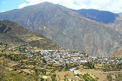 | ||
Sarhua is a district in the western Víctor Fajardo Province in Peru. It is bordered by Vilcanchos District on the west, Totos District (Cangallo Province) on the north, Huamanquiquia District on the east, and Santiago de Lucanamarca District (Huanca Sancos Province) on the south.
Contents
Map of Sarhua District, Peru
Geography
Some of the highest mountains of the district are listed below:
Ethnic groups
The people in the district are mainly indigenous citizens of Quechua descent. Quechua is the language which the majority of the population (98.00%) learnt to speak in childhood, 1.90% of the residents started speaking using the Spanish language (2007 Peru Census).
References
Sarhua District Wikipedia(Text) CC BY-SA