
Province Leinster Country Republic of Ireland | ||
 | ||
Tributaries Right:(artificial link from Naniken River) | ||
Santry River (Irish: Abhainn Sheantraibh) (formerly Skillings Glas) is a fairly small river on the north side of Dublin city, one of the forty or so watercourses monitored by Dublin City Council.
Contents
Map of Santry River, Dublin, Ireland
Course
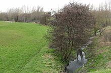
The Santry rises at an elevation of c. 80m, in the semi-rural areas of Harristown and Dubber in the part of County Dublin now administered by Fingal County Council, near the village of St. Margaret's and Dublin Airport. The lead branch can be found at the end of a small lane in the former Harristown Demesne, now cut off by new road development. The river then flows along to the south of Dublin Airport (from which some tributary streams enter it), near the new Dublin Bus Harristown depot. With the Dubber branch, it passes for most of its upper course out in the open, flowing through Sillogue Public Golf Course and then more of Ballymun; up to this point, the main channel is called Quinn's River.
The river traverses Santry, from which its main modern names comes, where it forms a major feature of the Santry Demesne, with small lakes within what is now the public park. In Coolock, the river forms a central feature in the valley which cuts through the district, and features ornamental ponds, running past the Stardust Memorial Park, and through the grounds of Cadbury's Ireland, where there is an EPA monitoring station, and a tumulus on its banks.
The Santry then enters Raheny near the beginning of Tonlegee Road, flowing alongside the Edenmore lands, past St. Joseph's Hospital, through the village centre, alongside the grounds of Manor House School, and then, with two areas of culverting, at the beginning and end of the former Bettyglen Estate, reaches the sea, where its mouth forms part of the eastern "lagoon" behind North Bull Island, and the flow enters Sutton Creek. The lower stretch of the river is occasionally noted as "Raheny River."
Drainage link from Naniken River
The dotted line on the above sketch is an artificial link made by Dublin Corporation between the Santry River and the Naniken River, to reduce the flow of the latter and to allow handling of any flooding in either watercourse. It runs at the western end of Kilmore West in Coolock.
Studies
As part of the management of the river, the Santry is one of the third tier rivers being numerically mapped within the Greater Dublin Strategic Drainage Study, with floodplain hydraulics computed (the other rivers being the Carrickmines, Deansgrange or Kill of the Grange, Poddle, Camac, Finglas and Mayne, along with one of the two second tier waterways, the Tolka).
Incidents
The Santry has been noted for pollution incidents over the years, with industrial effluent and building material the most common causes (some of the latter once caused the main pond by the Stardust Memorial to be drained and reformed).