
Native name An Poitéal Length 6 km Mouth River Liffey Country Republic of Ireland | River system River Liffey Source Tallaght Province Leinster | |
 | ||
Main source Cookstown, Tallaght, County Dublin River mouth Discharges into River Liffey at Wellington Quay (Map) Tributaries Left:
Commons Water (Coombe Stream) | ||
River poddle in dublin s city centre previously unseen
The River Poddle (Irish: An Poitéal) is a river in County Dublin in Ireland. The city of Dublin is named after a "dark pool" (dubh linn, in Irish) that was once on its course. It rises in the Cookstown area, north of Tallaght, and flows into the River Liffey in the centre of Dublin.
Contents
- River poddle in dublin s city centre previously unseen
- Map of River Poddle Dublin Ireland
- OriginsEdit
- City WatercourseEdit
- The TongueEdit
- Lower courseEdit
- Dubh Linn and the origins of DublinEdit
- HistoryEdit
- Water supplyEdit
- References
Map of River Poddle, Dublin, Ireland
OriginsEdit
The Poddle begins as the Tymon River in the Cookstown area northwest of Tallaght village, near the site of Fettercairn House, and flows east, through Tymon North, and northeast, forming the northern border of Templeogue, towards Greenhills. Additional ponds were added to its course when Tymon Park was formed in the 1980s and 1990s. The river flows from Greenhills into Kimmage, where it used to receive an artificial stream from the direction of Templeogue. This, the City Watercourse, carried water from the River Dodder extracted at Balrothery Weir.
City WatercourseEdit
The Poddle's modest volume was increased for over 700 years by the significant addition of water diverted from the River Dodder at the great weir at Balrothery, north of Firhouse, and carried by the three-kilometre first section of the City Watercourse. The ancient watercourse was
The TongueEdit
The river is split at "The Tongue" at Mount Argus monastery in Harold's Cross, with one third of the flow forming the second section of the City Watercourse, heading for Crumlin Road and Dolphin's Barn, and two thirds continuing along a form of the original river bed. In the 1990s, changes were made in the Kimmage area, including the addition of a large fountain to the river.
Lower courseEdit
The line of the two Poddle flows later recombine and pass under much of the south city centre in a culvert. The final stages of the river's flow are complex, with related waters separating and joining. Linked flows include the Tenter Water, and the river is joined by the Commons Water from the Coombe, and ultimately Crumlin. The present main course is itself a diversion, the Abbey Stream, of the original course, which ran further east.
Nowadays, much of the lower course of the Poddle is in a large brick tunnel under the city streets and Dublin Castle, and while access is restricted, it is walkable.
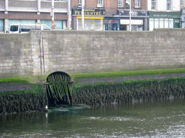
The confluence of the Poddle and the Liffey is visible at low tide at a grated opening in the Liffey walls at Wellington Quay (picture below).
Dubh Linn and the origins of "Dublin"Edit
A large, dark pool once existed at the confluence of the Rivers Poddle and Liffey; this pool was described in Irish as dubh linn, which means dark pool or black pool. The city name, Dublin, is an anglicisation of this Irish phrase. This historic pool existed under the present site of the Coach House and Castle Gardens of Dublin Castle.
During the ninth century, Vikings established themselves as Kings of Dublin, and based their settlement around the confluence of the two rivers, upstream from the Stayne long-stone.
HistoryEdit
The Poddle was known colloquially as the river Salach, or "dirty river" in Irish. A variation of this name is used in the old children's song The River Saile (or Weile Weile Waila), famously performed by The Dubliners.
In 1592, Red Hugh O'Donnell and Art O'Neill escaped from Dublin Castle through a drain into the Poddle which runs under the castle from Ship Street gate to the Chapel Royal and the Undercroft. The Poddle was later used to provide a water defence for the south wall of the castle.
For centuries the Poddle, progressively culverted, caused regular flooding and constant dampness in many buildings in the Blackpitts to St. Patrick's Street areas, including St. Patrick's Cathedral. For much of this time, a special public body, the Poddle Commission, operated, working to manage this, and with the power to raise a special tax to support its work. During a major reconstruction of the cathedral in the nineteenth century, the graves of Dean Jonathan Swift and Stella were moved to their present location, due to the problem of the Poddle.
Water supplyEdit
The river provided an early source of water for the city as the Liffey was tidal within the city area, and undrinkable, and the other major south-side water, the Camac, was too far from the main settlement (although there may have been a channel diverting some flow from it), while the Stayne River was too small. By the 13th century the water supply was inadequate and a deal was made, in 1244/1245, with the Priory of St. Thomas to divert water from the Dodder at the weir at Balrothery near Firhouse to the Poddle, to provide the greater part of the water flow. As mentioned, this connection was allowed to dry out in the late 20th century, and only a tiny part still carries water, though ample evidence of the watercourse can be seen: the sluices and channel on the north side of the Firhouse weir still stand.