
Visitors 609,636 (in 2011) | Established November 10, 1978 | |
 | ||
Area 156,671 acres (634.03 km) Similar Santa Monica Mountains, Malibu Creek State Park, Point Mugu State Park, Solstice Canyon, King Gillette Ranch | ||
Santa monica mountains national recreation area cool facts
The Santa Monica Mountains National Recreation Area is a United States National Recreation Area containing many individual parks and open space preserves, located primarily in the Santa Monica Mountains of Southern California. The SMMNRA is located within the greater Los Angeles region, with two thirds of the parklands in northwest Los Angeles County, and the remaining third, including a Simi Hills extension, in southeastern Ventura County.
Contents
- Santa monica mountains national recreation area cool facts
- Santa monica mountains national recreation area crenshaw hs kids 2
- Geography
- Park history
- Griffith Park
- National Forest
- Whitestone National Park
- Fredrick Law Olmsted
- Rindge bankruptcy
- Will Rogers State Historic Park
- Toyon National Park
- Point Mugu State Park
- Topanga State Park
- Malibu Creek State Park
- Establishment of the National Recreation Area
- Continuing land acquisitions
- Rim of the Valley Trail Corridor Study
- Superintendents
- Recreation
- Entrances
- Vehicles
- Parks
- References
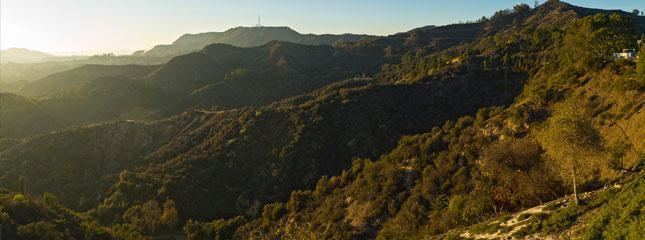
Overall administration is by the National Park Service, coordinating with state, county, municipal, and university agencies. The Santa Monica Mountains Recreation Area preserves one of the best examples of a Mediterranean climate ecosystem in the world. It also protects one of the highest densities of archaeological resources in any mountain range in the world.
Santa monica mountains national recreation area crenshaw hs kids 2
Geography
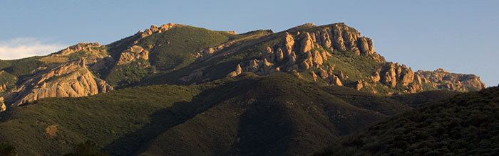
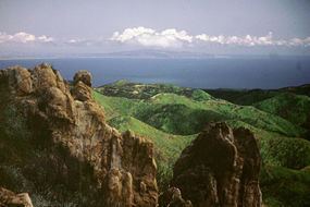
The Santa Monica Mountains NRA contains 156,671 acres (63,403 ha) in the Santa Monica Mountains of the Transverse Ranges between the Pacific Ocean and inland valleys. Its southeastern slopes are part of the headwaters of the Los Angeles River. The California State Park system owns 42,000 acres (17,000 ha), the National Park Service controls 23,620 acres (9,560 ha), and the rest of the SMMNRA lands are in local agencies parks, university study reserves, and private property conservation easements. In size the Santa Monica Mountains National Recreation Area is the largest urban national park in the United States.
Park history
The movement to preserve the Santa Monica Mountains has a long tradition which is frequently overlooked by historians who often focus exclusively on the environmental movement of the 1960s and 1970s which culminated with the establishment of the Santa Monica Mountains National Recreation Area in 1978.
Besides geologic forces, people who inhabited the area in the past have been ones to also affect the land. There were different reasons for people to come into the area. Some came to live and others to work the land. The first groups to live in the mountains were the Native American tribes called the Chumash and the Tongva who lived here for thousands of years. Then came the Spanish Explorers, Rancheros, and Homesteaders (after the Homestead Act of 1862) from other areas of the country, who worked the land. The Homesteaders brought new ideas and cultures that shaped the landscape and mindset of the area, and California overall. Up to this day, people continue to live, work, and recreate in the Santa Monica Mountains.
Places such as Paramount Ranch, Solstice Canyon, and Rancho Sierra Vista/ Satwiwa still have that history that has been left behind by people in the past. The past stories from these people are discovered through photographs, letters, to even things they threw away. Santa Monica Mountains National Recreation Area strives to make sure the collections, places, and stories of the people who affected the landscape will be preserved for the future.
Griffith Park
The first area in the Santa Monica Mountains set aside for public use was Griffith Park which was donated to the city of Los Angeles by Griffith J. Griffith in 1896.
National Forest
During the first decade of the twentieth century, Frederick H. Rindge made several attempts to create a forest reserve in the Santa Monica Mountains. These reserves were precursors to national forests. In 1902 California’s State Mining Bureau examined the area being considered for the establishment of a forest reserve. The resulting report was sent to Washington where the proposal for a reserve was denied.
In 1907 an application was submitted to the Secretary of the Interior requesting that at least 70,000 acres in the mountains be designated a forest reserve. This time state mineralogist Lewis E. Aubury opposed the venture. He wrote the L.A. Time newspaper stating, “I believe that the lands embraced in the Malibu and Santa Monica districts should not be included in a forest reserve…I shall at once take the matter up with Gifford Pinchot, forester, Washington, D.C., and endeavor to ascertain his views on the subject, and further protest against the creation of this proposed reserve”. Days later the U. S. Forest Service advised Aubury that it was highly improbable that a forest reserve would be created owing to local opposition and the small amount of public land still remaining in the Santa Monica Mountains.
Whitestone National Park
Limestone deposits were discovered in the mountains behind Pacific Palisades in 1925 which led to a lengthy battle between wealthy home owners of the area and land developers. The quarry site was in Traylor Canyon, three miles inland from the sea, between Santa Ynez and Temescal Canyons. Alphonzo Bell, Sr. was the real estate developer behind the quarry scheme while local opposition was led by Sylvia Morrison, who championed the preservation of the area’s natural beauty.
After much criticism of his original plan, Bell offered a new proposal. Using a new process, he would have the rock pulverized, mixed with water, and pumped via a buried pipeline to the mouth of Santa Ynez Canyon. The pipeline would continue from there along the ocean floor to an offshore buoy where it would be load on board a waiting ship. Criticism of the plan grew and eventually garnered the ire of local resident Will Rogers who parodied the plan on the front page of the L.A. Times. The debate raged citywide with such notable public figures as William Mulholland coming to Bell’s defense.
In an attempt to sway public opinion, Bell urged local residents to take company-sponsored fieldtrips, on foot and on horseback, to the quarry to see the site for themselves. Among the people who took these trips was Sylvia Morrison, who had been an early leader of environmental concerns. She was among the visitors who scrambled up the limestone cliffs on ladders and hiked and rode on horseback through the chaparral and came away thrilled with the natural beauty of the canyons. “Taking a cue from Yellowstone National Park, Morrison urged the establishment of Whitestone National Park in the Santa Monica Mountains, named after the by-now infamous cliffs.”
Fredrick Law Olmsted
In 1930 Frederick Law Olmsted, Jr., a lifelong advocate of national parks and considered by many as the designer of the California State Parks system, proposed a network of parks, beaches, playgrounds, and forests to promote the social, economic, and environmental vitality of Los Angeles. Olmsted also advocated for public ownership of at least 10,000 acres of the most scenic beach and mountain landscapes between Topanga and Point Dume. However, the Olmsted report was essentially killed – only 200 copies were printed – due mainly to civic leaders who put politics ahead of public space.
Rindge bankruptcy
After lengthy court battles to preserve her estate, May Rindge (widow of Frederick H. Rindge) lost control of her lands and was forced into bankruptcy in 1938. A proposal to establish a large park was considered in exchange for the cancellation of $1.1 million in unpaid taxes. However, Los Angeles County refused the offer, thus missing the opportunity to acquire 17,000 acres of park lands.
Will Rogers State Historic Park
Will Rogers State Historic Park was created in 1944 marking the establishment of the first state park in the Santa Monica Mountains and the first public land created in the mountains since Griffith Park in 1896. It now adjoins Topanga State Park on its northeast side.
Toyon National Park
In the 1960s and 70s, and possible as early of the 1950s, another campaign was undertaken to preserve the Santa Monica Mountains. Several proposals went before the U.S. Congress which called for the creation of Toyon National Park, referring to a dominant chaparral plant found in the area.
The legislative history of Toyon National Park dates back to 1971 when Representative Alphonzo Bell, Jr. first introduced a bill in the Congress.
Point Mugu State Park
Point Mugu State Park was the first of three large, rural state parks in the Santa Monica Mountains was established in 1967, when the State Division of Beaches and Parks, the forerunner of California State Parks, acquired title to 6,700 acres (2,700 ha) acres of the old Broome Ranch for $15.1 million. This property was the first acquisition for Point Mugu State Park, and was part of the 19th century Mexican Rancho Guadalasca. 5,800 acres was purchased from Richard E. Danielson in 1972 for $2.1 million, nearly doubling the park's acreage. This property is situated northeast of the park's original 6,700 acres and consisted of mostly backcountry. A remaining 850-acre parcel which adjoined this property was purchased by the Santa Monica Mountains National Recreation Area from Danielson in 1980, becoming Rancho Sierra Vista open space park.
Topanga State Park
Topanga State Park was opened to the public in 1974. The park's original name was Topanga Canyon State Park, but the name was shortened because the 11,525 acres (4,664 ha) park encompass large areas outside Topanga Canyon, from the Pacific Coast Highway to Mulholland Drive. The park can be accessed by car and trails from Topanga, and by trailheads in Pacific Palisades and the San Fernando Valley.
Malibu Creek State Park
In the heart of the Santa Monica Mountains, the 20th Century Fox Movie Ranch, commonly called Century Ranch, was a 2,700-acre land acquisition of what would become Malibu Creek State Park. It was purchased by the State of California in 1974 for $4.8 million. Reagan Ranch, a 120-acre property on the west and formerly owned by Ronald Reagan, was included in the original Century Ranch purchase. The Hope Ranch, owned by entertainer Bob Hope and which abutted Century Ranch, was purchased in 1975 for $4.1 million. In 1976 the State Parks and Recreation Commission adopted a compromise on the classification of the Century Ranch property, and officially named it Malibu Creek State Park.
Establishment of the National Recreation Area
The Santa Monica Mountains National Recreation Area was established November 10, 1978, after a long campaign for preservation of the Santa Monica Mountains by local and regional conservationists. Susan Nelson helped organize "Friends of the Santa Monica Mountains, Parks and Seashore" in 1964 and was known as the mother of the Santa Monica Mountains National Recreation Area. In 1988 though, she was concerned about the political push to end federal land purchases encouraged by Los Angeles County developers that preferred the land stay available for home building. She was encouraged though that neighboring cities in Ventura County were supportive of park expansion.
The strategy has been to grow SMMNRA by 'mosaic pieces' linking critical habitats, saving unique areas, and expanding existing parks. The Santa Monica Mountains Conservancy, a California state agency, was created in 1980 for the acquisition of land for preservation as open space, for wildlife and California native plants habitat preserves, and for public recreation activities.
One of the first land acquisitions was Rancho Sierra Vista in 1980 which is reputed to be one of the last intact ranches from the first half of the twentieth century in the Santa Monica Mountains.
Continuing land acquisitions
In 1980 the Paramount Movie Ranch was acquired in Agoura Hills, and is the present day Paramount Ranch Park. The National Park Service revitalized the old movie ranch, and it is again used for movie and television productions, and is open for public recreation and events.
Entertainer and land speculator Bob Hope created controversy in the early 1990s when he proposed to sell 5,900 acres (2,400 ha) of land in the Corral Canyon area in the Santa Monicas to the federal government in exchange for 59 acres (24 ha) of federal parkland in the nearby Cheeseboro Canyon section of Santa Monica Mountains NRA in the Simi Hills, in order to build an access road to a new 'Jordan Ranch' golf course and housing development. The land swap was never completed, the Jordan Ranch became the Palo Commado section of the Cheeseboro Canyon / Palo Comado Canyon Open Space parks. Most of the land for the 1,000 acres (400 ha) Corral Canyon Park was finally donated by Bob Hope.
The former Ahmanson Ranch was acquired by the Santa Monica Mountains Conservancy from Washington Mutual in 2003, to create the 2,983 acres (1,207 ha) Upper Las Virgenes Canyon Open Space Preserve in the southeastern Simi Hills. It is adjacent to and has trailheads in Calabasas (Las Virgenes Trailhead), Woodland Hills (Victory Trailhead), and West Hills via Moore's Canyon in El Escorpión Park.
The highly visible hills with undeveloped ranch land adjacent to the junction of U.S. Route 101 and Las Virgenes Road in western Calabasas, the former Brent's Junction area, have several viewsheds now protected from development. They also serve as an unofficial gateway to the central Santa Monica Mountains National Recreation Area and its visitors center on Las Virgenes Road at King Gillette Ranch. On the southeastern side the land was formerly owned by Bob Hope, acquired by the SMM Conservancy in 2010, and added to the Las Virgenes View Park in the Santa Monica Mountains NRA. The viewshed on the northwestern side of the junction, formerly owned by Fred Sands, was acquired in 2010 and protected in the 200 acres (81 ha) Zev Yaroslavsky Las Virgenes Highlands Park. Both preserve refreshing open space that's seen by many travelers on the Ventura Freeway (101) between the San Fernando and the Conejo Valleys. The area was originally along the Spanish and Mexican El Camino Real.
Rim of the Valley Trail Corridor Study
The Rim of the Valley Corridor Special Resource Study is being conducted by the National Park Service, and generally includes the mountains encircling the San Fernando, La Crescenta, Santa Clarita, Simi, and Conejo Valleys in Los Angeles and Ventura Counties. The SMMNRA is part of the Rim of the Valley Trail Corridor planning process, and several alternatives include a Rim of the Valley a SMMNRA boundary adjustment (of an approximately 173,000-acre or 313,000 acre addition). The Rim of the Valley Trail is a plan in progress for connecting the four valleys with the parklands surrounding them.
Superintendents
Recreation
The Anthony C. Beilenson Interagency Visitor Center at King Gillette Ranch was opened in June 2012, and is operated by four partner agencies: National Park Service, California State Parks, Santa Monica Conservancy, Mountains Recreation and Conservation Authority. It is located at 26876 Mulholland Highway, Calabasas, CA, 91302.
The Satwiwa Native American Indian Culture Center is the only site in the National Park Service dedicated to the past, present, and future of all Indian cultures. A Native American guest-host or a park ranger is on hand to answer questions from 9am to 5pm on Saturdays and Sundays. Native American workshops, programs, and art shows occur throughout the year. Satwiwa means "bluff" in the Chumash language and refers to the cliffs of Boney Mountain which can be seen from Satwiwa. The center is located at Rancho Sierra Vista in Newbury Park. Main Entrance cross street is Via Goleta and Potrero Road.
The main headquarters for the park is located at 401 West Hillcrest Drive, Thousand Oaks 91360.
Recreational opportunities abound, including biking, birding, land-based whale watching, camping, hiking, and horseback riding. The Backbone Trail runs for nearly 70 miles (110 km) across the Santa Monica Mountains between Will Rogers State Park and Point Mugu State Park and is nearly complete from end to end. Channel Islands National Park lies in the Pacific Ocean directly to the west.
Entrances
Main entrances to the SMMNRA include Malibu, Newbury Park, Agoura Hills, Calabasas, Woodland Hills, and Topanga, California.
Vehicles
Parks
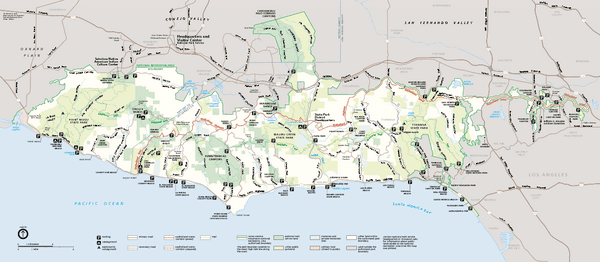
The following parks and areas are managed by the National Park Service in the Santa Monica Mountains NRA:
The following California State Parks are located within Santa Monica Mountains NRA:
State Beaches in or adjacent to Santa Monica Mountains NRA: