
County Sogn og Fjordane Area 230 ha Population 2,213 (2013) | Elevation 10 m (30 ft) Local time Tuesday 9:59 AM Number of airports 1 | |
 | ||
Weather 5°C, Wind S at 11 km/h, 84% Humidity | ||
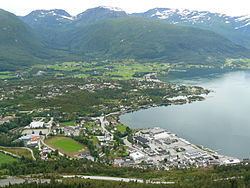
Sandane is the administrative centre of the municipality of Gloppen in Sogn og Fjordane county, Norway. It is located at the end of the Gloppefjorden, along the European route E39 highway. Sandane is 20 kilometres (12 mi) south of the village of Nordfjordeid and about 16 kilometres (9.9 mi) west of the village of Byrkjelo. Sandane Airport, Anda is located 10 kilometres (6.2 mi) northwest of Sandane along highway E39. Sandane has several suburban areas that surround the nearby fjord such as Sørstranda to the west and Vereide to the northwest.
Contents
Map of 6823 Sandane, Norway
The 2.3-square-kilometre (570-acre) village has a population (2013) of 2,213; giving the village a population density of 962 inhabitants per square kilometre (2,490/sq mi). The Firda Upper Secondary School and Sandane Church are both located in Sandane. Sandane is located close to the lake Breimsvatn, the Myklebustbreen glacier, and Jostedalsbreen National Park.
Culture
The Glopperock festival has been held in Sandane since 1980.