
Phone +47 480 02 997 | Area 1,310 km² Established October 25, 1991 | |
 | ||
Governing body Directorate for Nature Management Hours Open today · Open 24 hoursTuesdayOpen 24 hoursWednesdayOpen 24 hoursThursdayOpen 24 hoursFridayOpen 24 hoursSaturdayOpen 24 hoursSundayOpen 24 hoursMondayOpen 24 hours Similar Briksdalsbreen, Nigardsbreen, Breheimsenteret, Jotunheimen National Park, Jostedalsbreen nasjonalparksenter | ||
Norway part 5 jostedalsbreen national park
Jostedalsbreen National Park (Norwegian: Jostedalsbreen nasjonalpark) is a national park in Norway that encompasses the largest glacier on the European mainland, Jostedalsbreen. The park was established by royal decree on 25 October 1991, and then in 1998, it was enlarged to the northwest. The park now covers 1,310 square kilometres (510 sq mi), with the glaciers covering about 800 square kilometres (310 sq mi) of the park.
Contents
- Norway part 5 jostedalsbreen national park
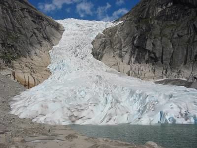
- Briksdal glacier entering the jostedalsbreen national park
- Location
- Topography
- Name
- References
Briksdal glacier entering the jostedalsbreen national park
Location
The park lies in the municipalities of Luster, Balestrand, Jølster, Sogndal, Gloppen, Førde, and Stryn, all of which are in Sogn og Fjordane county. There are three museums and also visitors centers: the Breheimsenteret in Jostedal, Jostedalsbreen nasjonalparksenter in Oppstryn (Stryn) and Norsk bremuseum in Fjærland.
Topography
The highest peak in the park is Lodalskåpa at 2,083 metres (6,834 ft). The glacier's highest point, Brenibba, lies 2,018 metres (6,621 ft) above sea level while its lowest point is 350 metres (1,150 ft) above sea level. The glacier has shrunk in recent years, and there are ruins of farms that were overtaken by the glacier in 1750.
Name
The park was named after the main glacier in it, Jostedalsbreen. The first element of that name is the name of the old municipality Jostedal, the last element is the finite form of the word bre which means "glacier".