
Elevation 6,820 ft (2,080 m) Country United States of America | ||
 | ||
Topo map USGS San Rafael Mountain Mountains | ||
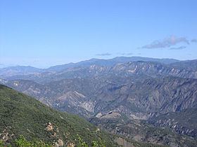
The San Rafael Mountains are a mountain range in central Santa Barbara County, California, U.S., separating the drainages of the Santa Ynez River and the Santa Maria River. They are part of the Transverse Ranges system of Southern California which in turn are part of the Pacific Coast Ranges system of western North America.
Contents
- Map of San Rafael Mountains California USA
- GeographyEdit
- PeaksEdit
- GeologyEdit
- HabitatsEdit
- Human historyEdit
- References
Map of San Rafael Mountains, California, USA
GeographyEdit
Most of the mountain range is within the Los Padres National Forest, and the northern slopes are included in the remote San Rafael Wilderness area.
The highest peaks include Big Pine Mountain (6,820 ft, 2,079 m), San Rafael Mountain (6,593 ft, 2,010 m) and McKinley Mountain (6,220 ft, 1,896 m), none of which are easily accessible except by foot or horse. The highest peak at the southern edge of the range is Little Pine Mountain.
Hurricane Deck is a spectacular block of sandstone that can be found deep in the San Rafael Wilderness.
The Sisquoc River headwaters are on the north slopes of Big Pine Mountain. It is a designated Wild and Scenic River of the United States, and a tributary of the Santa Maria River. Sisquoc Falls, 250 feet (76 m) high, is located on a tributary of the Sisquoc RIver to the west of Big Pine Mountain.
Climate is moderate, with hot dry summers (rare thunderstorms) and cool to cold wet winters. Snow sometimes falls on the higher slopes between December and March during frontal passages. Annual precipitation totals are between 15 and 25 inches.
PeaksEdit
The six highest peaks of the San Rafael Mountains with more than 500 feet (150 m) of prominence, listed by height:
- Big Pine Mountain, 6,820 feet (2,080 m)
- San Rafael Mountain, 6,593 feet (2,010 m)
- Madulce Peak, 6,539 feet (1,993 m)
- Monte Arido, 6,013 feet (1,833 m)
- Ortega Peak, 5,857 feet (1,785 m)
- Figueroa Mountain 4,534 feet (1,382 m)
GeologyEdit
The mountains mainly consist of sedimentary and metamorphic rocks, of Jurassic age or younger, though there are a few regions of igneous intrusions. Several prominent faults exist, including the Big Pine Fault, which trends eastward towards the San Andreas Fault about forty miles away.
HabitatsEdit
The mountains are steep and rugged, and lower slopes are covered with almost impenetrable chaparral, except where it has been burned, an event which occurs naturally in fire ecology every ten or twenty years . Decades of fire suppression, however, have resulted in some areas of brush which have not burned within the last century. The Forest Service occasionally conducts controlled burns to remove areas of high fire hazard and restore ecological balance of the habitat. In the more shaded and moist canyons and northern slopes oak woodlands and Gray pines (Pinus sabiniana ) are found.
Above the montane chaparral and woodlands ecosystem zone are stands of conifers of the mixed evergreen forest ecosystem. Snow is common in the winter on the summits, above about 6,000 feet (1,800 m), though overall the climate of the mountain range is Mediterranean, with mild rainy winters and warm, dry summers.
Human historyEdit
The earliest known residents of the San Rafael Mountains were the Chumash Indians, and evidence of their habitation can still be found by intrepid hikers in the form of pictograph rock paintings in remote areas.
In historic times, mercury mining was conducted on portions of the southern slopes. Tailings from these old mines sometimes contain high levels of mercury, and recent environmental investigations have been conducted to determine if cleanup is necessary and feasible.
The central part of the mountains is included into Santa Ynez Recreation area, a part of Los Padres National Forest, and is a popular hiking destination, with a dozen of campgrounds.