
Elevation 589 m (1,932 ft) Time zone CET (UTC+1) Local time Tuesday 1:10 AM Postal code 47865 | Demonym(s) Leontini | |
 | ||
Frazioni Agenzia, Capicchio, Castelnuovo, Montefotogno, Montemaggio, Pietracuta, Pietramaura, Santa Lucia, Tausano, Torello Weather 8°C, Wind S at 3 km/h, 83% Humidity | ||
San Leo is a comune (municipality) in the Province of Rimini in the Italian region Emilia-Romagna, located about 135 kilometres (84 mi) southeast of Bologna and about 35 kilometres (22 mi) southwest of Rimini.
Contents
Map of 47865 San Leo Province of Rimini, Italy
Geography
San Leo borders the following municipalities: Acquaviva (San Marino), Chiesanuova (San Marino), Città di San Marino (San Marino), Maiolo, Montecopiolo, Monte Grimano, Novafeltria, Sassofeltrio, Torriana, Verucchio.
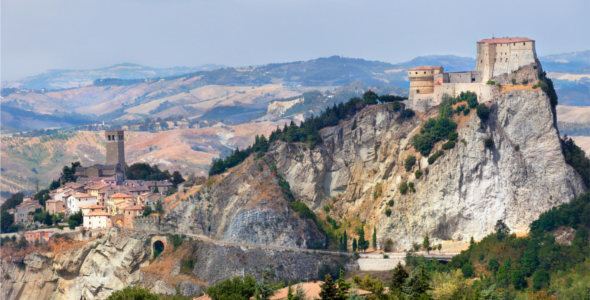
San Leo is home to a large fortress at an elevation of 600 metres (2,000 ft) above sea level. The San Leo Cathedral is a Romanesque architecture church in town.
History
After the referendum of 17 and 18 December 2006, San Leo was detached from the Province of Pesaro and Urbino (Marche) to join Emilia-Romagna and the Province of Rimini on 15 August 2009.