
Country Guatemala | Climate Cfb | |
 | ||
Department Alta Verapaz Department | ||
Romeo suram lider san crist bal verapaz
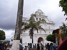
San Cristóbal Verapaz ([san kɾisˈtoβal βeɾaˈpas]) is a municipality in the Guatemalan department of Alta Verapaz. It is at approximately 29 km from Cobán, capital of Alta Verapaz and about 210 km from Guatemala City. San Cristóbal belongs to the Pokimchi' linguistic area. Its main income source is the «Cobán» shoe factory, which specializes in industrial rubber boots, which are sold both locally and internationally.
Contents
- Romeo suram lider san crist bal verapaz
- Map of San Cristobal Verapaz Guatemala
- Franja Transversal del Norte
- Famous citizens
- Climate
- Municipal distribution
- References
Map of San Cristobal Verapaz, Guatemala
Franja Transversal del Norte
The Northern Transversal Strip was officially created during the government of General Carlos Arana Osorio in 1970, by Legislative Decree 60-70, for agricultural development. The decree literally said: "It is of public interest and national emergency, the establishment of Agrarian Development Zones in the area included within the municipalities: San Ana Huista, San Antonio Huista, Nentón, Jacaltenango, San Mateo Ixtatán, and Santa Cruz Barillas in Huehuetenango; Chajul and San Miguel Uspantán in Quiché; Cobán, Chisec, San Pedro Carchá, Lanquín, Senahú, Cahabón and Chahal, in Alta Verapaz and the entire department of Izabal."
San Cristóbal Verapaz was not part of the Strip, but it was bordering it and felt the devastating effects of the Guatemala Civil War which was fought mainly in the Strip during the 1980s.
Famous citizens
Climate
San Cristóbal Verapaz has temperate climate (Köppen: Cfb).
Municipal distribution
The rural area of the municipality has eighty nine communities, while the villa has five neighborhoods: Santa Ana, San Felipe, San Cristóbal, San Sebastián y Esquipulas. The municipality is divided into the following microregions:
There are eighteen populated locations that are considered the most important due to the number of inhabitants and utility availability and access: