
Location Atlantic Ocean Length 35 km (21.7 mi) Highest elevation 406 m (1,332 ft) | Area 216 km (83 sq mi) Width 12 km (7.5 mi) Highest point Monte Vermelho | |
 | ||
Sal (Portuguese for “salt” — from the mines at Pedra de Lume) is an island in Cape Verde. It belongs to the northern group of islands, called Barlavento ("windwards"), and comprises a single administrative division, the Sal municipality. The island is home to Amílcar Cabral International Airport, the main airport of Cape Verde.
Contents
- Map of Sal Cape Verde
- History
- Geography
- Climate
- Demographics
- Economy
- Infrastructure
- Settlements
- Twin towns Sister cities
- Notable residents
- References
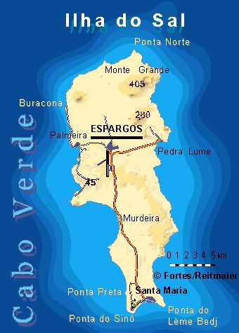
Map of Sal, Cape Verde
History
The island was discovered on December 3, 1460 and named Llana until salt deposits were found at the end of the 18th century in Pedra de Lume. In the early years, slaves grazed parts of the island, in the 17th century, free settlers took salt. Sal is the geologically oldest island in Cape Verde, formed 50 million years ago during the eruption of a volcano which is now inactive.
Salt activity was not active until 1800. Sal at the time was the leastly populated island in Cape Verde, once had around or the same as Santa Luzia. Santa Maria was founded in the south in 1835 by Manuel António Martins who became governor and became the island capital, the salt industry thrived, in its early years 30,000 tons of salt were exported. Most of the salt was exported to Brazil until its nationalization in 1887, Portuguese and French salt investors resumed salt production until 1984. Three lighthouses were constructed at the island's extreme points in the 1880s. An airport first constructed by Italy started construction in 1939 to receive flights to Europe and South America, construction was halted in around 1940 during World War II and continuation ceased, the Portuguese bought the airport from the Italians and finished the rest in 1949, planes from Italy would offer a stopover flight for refueling planes for flights with South American cities. Northeast of the airport, workers from São Nicolau Island to the west would settle a village and was named Preguiça, where the first settlers originated and the youngest urban center in Cape Verde, Palmeira was later founded and became the island's other port, not long after it became Espargos due to the asparagus plants founded there and became the main island capital as well as a commercial center, a part of the population growth even to the present continue to arrive from São Nicolau. Unlike other parts of Cape Verde, famine did not devastate the island as the population was only about 500 in 1930 and one of some islands up to 1970 that the population continued to grow. Farmlands were established around 2 km northwest of Espargos in the mid 20th century. A new solar electricity station was established in around 2010 and located 1.5 km north of Santa Maria on the main road, the first and only in Cape Verde. A large growing population has now led to the division of the municipality, it was first plan on April 7, 2014, no date of the separation has been set. It would form the municipalities of Espargos and Santa Maria, the municipal boundary would be marked north of Ilhéu Rabe de Junco, north of Murdeira and south of the airport, probably in the east-west line, also Nossa Senhora das Dores will exclude Santa Maria. Hurricane Fred struck the island of Sal in late summer 2015, the hardest was on August 31, in Santa Maria, his storm surge sunk or stranded dozens of vessels and destroyed an important tourist pier. Hotels, restaurants, and other beach facilities were flooded, and roads in the town became impassable. High winds leveled the roof of a sport center at a gymnasium which had initially been set up as a storm shelter to about 100 citizens. Elsewhere, the hurricane knocked out power to homes in Palmeira and caused minor structural damage to Sal International Airport.
Geography
The island is 35 km long by 12 km wide. It is one of the three sandy eastern islands (Sal, Boa Vista and Maio) of the archipelago, with white sandy beaches and fairly flat. The highest elevation of 408 m is at Monte Grande. Serra Negra has a height of 92 m.
Sal are one of five islands that have one or more surrounding islets, it is Ilhéu Rabo de Junco
Climate
Sal Island has on average 350 days of sunshine a year. Winds mainly blow from the northeast. However,some days do also have clouds, but they tend to be scattered and seldom bring rain. The 'rainy season' is from July to mid-October, although rainfall is still low.
Demographics
As of 1832, the population was estimated at 400 people. The population reached 1,000 around the early 20th century, once the least populated island of the nine inhabited, the population started growing moderately large the population more than doubled between 1950 and 1960 and rose more than 10% a year to 5,505 in 1970, until 1990, its growth was moderate, another large population growth occurred which brought the population to nearly 15,000 at the end of the 20th century, in 2010, the population reached 35,000, urban sprawl spread to east of Espargos hill by up to 1,5 km and the northern and western part of Santa Maria along with its hotels and villas first developed in 2006. The island population is now around 40,000 and is now the fifth most populated island in Cape Verde, in 1990, it surpassed Brava's population, in 2000, it surpassed the neighboring São Nicolau's population.
Economy
Sal’s main town, Cidade dos Espargos, is home to one of the nation’s international airports and has around 32,000 [2015] inhabitants. Its population grew around salt collection and later shifted to fishing, but is now based on tourism (amounting to 50% of the archipelago’s tourism) at the beach resort of Santa Maria. The living standards on the island is among the best in the Cape Verde archipelago. The island's GDP per capita as of July 2015 is roughly US$7068,00.
Its airport, Amílcar Cabral International Airport, was used as a refuelling base by South African Airways on its Johannesburg to London routes. This was necessitated by the refusal of Black African states to the North to grant overflying permission and direct routing to and from Europe during apartheid. Later, flights to and from New York and Atlanta also refuelled there, and the island was a crew-change station. SAA established the long runways needed by the fully fueled Boeing 747s on their take-offs in the high temperatures. On July 1, 2006, SAA operated its final flight to Sal due to the ending of its flights to Atlanta.
Saline marshes can be found in the Pedra de Lume crater and north of Santa Maria.
Infrastructure
The major roads on the island are:
Settlements
There are six inhabited centers:
Other inhabited settlements are:
Twin towns - Sister cities
Sal is twinned with: